What is Hail?
Hail are balls or pieces of ice from 3 mm to more than 50 mm in size. Because the formation of hail usually requires convective clouds with strong updrafts, hail is often associated with thunderstorms.
Hailstorms usually last about 15 minutes and usually occur in the middle to late afternoon. South Africa is prone to severe hailstorms, being situated in the mid-latitudes - temperate zone between 30 and 60 degrees north and south of the equator.
How is Hail Formed?
Hailstorms require strong updrafts, sufficient ice nuclei and super-cooled water to form. For the smallest hailstone to form an updraft of around 35 - 55 km/h is required. Larger stones, the size of golf balls, 40 mm diameter, require updrafts of around 90 km/h to form.
Hailstones begin forming on seeds of small frozen raindrops or soft ice particles known as graupel - hardened masses of snowflakes. In order for the frozen raindrops or graupel to grow into true hailstones, they must accumulate additional ice, a process called accretion. To do so, the hail embryo must spend time in clouds rich in supercooled water where temperatures are below 0°C.
Hailstones fall as a result of an increase to a size unable to be countered by storm cell’s updrafts, or they may be caught in a downdraft and hurled earthward. Large hailstones fall at speeds of over 160 km/h. Most hail either melts before hitting the ground or disintegrates in the violent thunderstorm interior.
Hail Areas in South Africa

A farmer should not be complacent about farming in an area having low frequencies of hailstorm occurrence as the impact of even one hailstorm can have a serious economic impact on crop production. For example, table grape producers in the Waterberg area of Limpopo Province who experience ‘only’ one to three hailstorms per year, install expensive hail nets to cover vineyards.
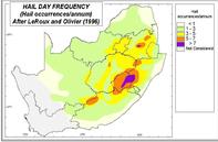
Hail occurrences are higher in the interior of KwaZulu-Natal, the northern and western parts of the Eastern Cape, central Free State and on the Highveld areas of Gauteng, eastern Free State and Mpumalanga than in other areas of South Africa.
Hail Belts in South Africa
There are hailstorm ‘hotspots’ or ‘hail belts’ in South Africa. These areas have a much higher hailstorm frequency than the surrounding areas.
The Misgund area in the Langkloof Valley, one of South Africa’s main deciduous fruit production areas, under irrigation, is a hailstorm hotspot, suffering regular losses. Another big hail belt stretches along the southern slopes of the Winterberg Mountains in the Eastern Cape from north of Somerset East to north of Fort Beaufort.
Commercial citrus farmers in the Kat River Valley near Fort Beaufort have suffered great losses due to regular severe hailstorms. In the Eastern Cape, the December and January hail storms are characterised by very large hailstones, larger than a hen’s egg.
It is also important to know when the ‘hail season’ for a specific area is, because the crop stage at which a hailstorm strikes makes a big difference to the damage caused. Unfortunately, information regarding hailstorm frequency, hotspots or hailstone sizes cannot be obtained from meteorological records.
Source Water Research Commission