
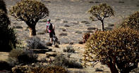
Remarkable Bio-Diversity
The biodiversity of the Richtersveld and Namaqualand is remarkable. But this is an arid region with an average annual rainfall of around 150 mm, making it technically a desert.
It’s also very hot, with summer temperatures often soaring to around 50 degrees. So, how can such an inhospitable place succour such a rich botanical heritage? Well, there are several climatic conditions that have conspired to create this unlikely Eden.
The first important element to consider is the cold Benguela Current, which flows in a northerly direction up the west coast of the sub-continent. The Benguela originates in the Antarctic region, where the warmer water of the Atlantic mixes with the icy Southern Ocean.
This meeting causes the warm water to cool and sink, causing an ‘upwelling’ of cold, nutrient-rich water from the bottom of the southern oceans. Powerful winds from the South Atlantic anticyclone system drive this stream of cold water up to the Cape of Good Hope and along the west coast. It finally peters out along the shores of Angola, when it meets with warmer equatorial currents.
The Benguela Current
The Benguela current has a major impact on the environment of the sub-continent. The nutrient rich waters support large stock of pelagic fish, which in turn support seals, water birds and other marine life.
The cold surface water, which is about 5 degrees cooler than the off-shore waters at equivalent latitudes, also limits the amount of evaporation that can occur. As a result, the rainfall along the west coast is low and the current has a generally ‘aridifying’ effect on the region. But the Benguela Current has its upside in that it has a stabilising effect on the region.
The cool winds that blow in off the sea moderate the temperature of the coastal belt, so the summers aren’t too hot and the winters aren’t too cold. However, because of the mountains, these sea breezes do not penetrate into the interior and summer temperatures in the Richtersveld can soar well above 40 degrees.
The Benguela current is also the source of thick, moisture-laden fogs that regularly roll in from the coast. These heavy mists, known as malmokkies or !hurries by the locals, are created when humid air blows in from the west and is cooled down by the cold surface water.
This forces the warm air to condense into a thick fog that creeps over the coastal plains, covering the plants with a fine haze of moisture. Occurring mainly in the autumn months, when the wind speeds are low, these malmokkies are a regular occurrence and a crucial component of the region’s relative fertility.
The Malmokkies
The reliability of the malmokkies is supplemented by a surprisingly regular rainfall pattern. Unlike other desert regions, Namaqualand does not suffer prolonged periods of drought. So, while rainfall is low, it is reasonably constant and this allows plants to perpetuate their life cycles.
The reasons for this regular precipitation cycle are not well understood. The last important climatic condition which sustains the Namaqualand ecosystem is the Berg Winds which blow down from the South African interior every winter. This phenomenon is caused by a high pressure cell of dry air which descends on the high plateau.
The air is then drawn towards the low pressure systems along the coast, causing it to rush down the mountain slopes of the steep escarpment. As it descends through the valleys, the air is heated and becomes turbulent.
The result is hot, dry winds that blow across the coastal plains. In Namaqualand and the Richtersveld, these Berg Winds create warm winter temperatures that allow the plants and animals to develop and reproduce.
By David Fleminger