
The Geological Sequence
Over several hundred million years, the Earth began to cool down somewhat and the celestial bombardment diminished, probably because many of the bolides in the solar system had already crashed into something or been ‘used up’.
Water vapour, carbon dioxide and other gasses materialised out of the steaming cracks in the Earth’s surface and began forming the atmosphere.
Rain began to fall and seas started pooling on the rocky crust. Surface water was present by at least 3.9 billion years ago.
The Archaean Era
This is the start of the Archaean era (meaning ‘ancient’) and it lasted until about 2.5 billion years ago. During this time, belts of so-called Granite-Greenstone rock layers were formed, establishing the basement for all subsequent geological activity.
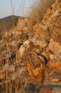
The best-preserved example of Archaean era crust still visible on Earth can be found in Mpumalanga, around the town of Barberton, where ancient Granite-Greenstone strata have been overturned and exposed on the surface. These volcanic rocks, called komatiities, formed on an ancient seabed between 3.6 and 3.2 billion years old.
Their composition indicates that they were formed at a time when temperatures in the mantle were considerably higher than they are today, which shows that the Earth has continued to cool off in the intervening millennia. As the crust continued to solidify, silica-rich material (which was less dense than the molten matter below) tended to rise up and collect on top of the mantle.
Since it was ‘lighter’ than both the mantle and the ocean floor, these silica-rich rocks were not subducted and remained floating on the surface, eventually getting thick enough to rise above the water level as islands.
Cratons
Over time, the newly-formed islands continued to drift on top of the tectonic plates, bumping into each other and consolidating, until sizable chunks of land had been formed at various locations on the Earth.
These amalgamations are called ‘micro-continents’. Simultaneously, rocks exposed above the water line proceeded to be eroded by wind and running water, and worn-down rock fragments were deposited along the periphery between the land and the ocean as gravel conglomerates, sandstones and mudstones. The first continent was taking shape.
To cut a long story short, these buoyant early continents continued to grow and, since they were less dense than the ocean floor, proved very difficult to subduct. Some sections of continental crust therefore remained more or less extant for the next 3 billion years. They may have split up and recombined several times, but they were not destroyed or recycled. Today, we call these stable pieces of ancient crust, ‘cratons’.
The Kaapvaal Craton
One of the earliest cratons on the planet is the Kaapvaal Craton, which still lies at the heart of Southern Africa. The original size of this craton is unknown, but analysis has shown that the eastern part of South Africa, western part of Australia, India and Madagascar were all once joined together in this ancient continent.
Over the years, newer rock layers were laid down on top of the craton’s Granite-Greenstone basement, along with an impressive amount of valuable minerals. The Kaapvaal Craton would also be the epicentre of the Vredefort impact. The first layer of new rocks to be formed on the Kaapvaal craton is called the Dominion group.
It consists of a thin layer of sedimentary rocks topped by a thicker layer of igneous rocks. Sedimentary rocks are created when fragments of eroded rocks are deposited in a new location and gradually turn into stone, through a process called lithification.
Igneous rocks, on the other hand, are created through volcanic activity in the upper mantle and crust, in which magma is injected up through cracks in the crust until it cools and solidifies. Lava flows that emerge on the Earth’s surface can also form igneous rocks.
By David Fleminger