
From the Waterfront, turn left and follow signs to N1 Paarl. Around 53 km take Exit 55, R45 (R101) Paarl Main Road and Franschhoek and turn left at the stop. At 55 km turn left onto Jan Phillips Drive, signed Paarl Mountain Reserve (becomes gravel). At 57 km T-junction right to Paarl Mountain Reserve. Pass a picnic area and toilets at 61km - park after 1 km and take an easy walk onto the top of Paarl Rock, but for more impressive rocks drive another 500m.
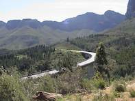
At 48 kilometres you'll see some swooping white stone columns up on a hill on the left. That's the Taal (Language) Monument, inaugurated in 1975 to commemorate the origin and growth of Afrikaans. A colossal cluster of granite domes that soar 654 metres into the sky sets the tone for this rocky route, named the Paarl ('Pearl') mountains by the very first European visitors because of the way they glisten when it rains.
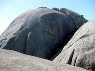
Paarl Rock, which dominates the town below, is the first boulder you come to - on top is an old cannon that used to be fired to tell local farmers a ship needing fresh produce had come into Table Bay - but keep going to the more impressive Britannia (on the left) and Gordon's rocks further up the road. There's an easy path to the top of Britannia Rock, from where you can see all the way to Table Mountain, with absolutely breathtaking 360-degree views of the Paarl Valley and the Peninsula.
Paarl Rock to Op-die-Berg via Ceres and Prince Alfred Hamlet
From the top parking area, follow the road down and through the boom. At 2.8 km, turn left - this is not signposted. At the stop (8 km) turn left, then right to the R45 to Wellington, Malmesbury. At 13 km turn right at the four-way stop to R44 Wellington. (Ignore next left to Hermon, Ceres) At the traffic lights and T-junction at about 18 km, turn left to Wellington. Bain's Kloof village is at the top of the pass at about 34 km. Ignore the right turn to Worcester at about 49 km and go straight to Wolseley, Ceres.
At 63 km, cross the Breede River and at the T-junction turn right to R46 Ceres and cross Michell's Pass. Enter Ceres. At about 73 km, turn left at the lights to R303 PA Hamlet, Op-die-Berg and Citrusdal. You'll pass through Prince Alfred Hamlet at about 81 km, and start the Gydo Pass. (Ignore the right to Touws River.) At 115 km, turn left into Op-die-Berg. The road almost all the way from Ceres is flanked by two starkly different mountain ranges.
The Swartruggens mountains rise serenely on the right, while on the left, the tormented rocks of the Witsenberg and Skurweberg lie scattered and shattered. Op-die-Berg is a tiny hamlet that's home to Wethu Experiences, a community-based project that will take you on an interesting two and a half hour rock art tour to three ancient sites, starting with an open living area, then a birthing site, and lastly through a 10 metre high tunnel to a fascinating shaman site. (This can be combined with a kid-friendly donkey cart excursion).
Wethu also offers mountain bike rides and hiking in the Skurweberg and the Swartruggens Nature Conservancy, which might be under snow around August and September. Booking for the Wethu tour is essential. The rock art site is en route to the overnight stops at Kagga Kamma or Mount Ceder.
If you'd like to go on from the site (instead of returning to Op-die-Berg with the guide), let them know in advance. It's not far to the two overnight spots - Mount Ceder's cottages on the river or Kagga Kamma, which is priced for the international market. Alternatives are Klein Cederberg (stone cabins, with rock art sites), Zoo Ridge guesthouse, Nuwerust (self-catering) and Rietvlei (B & B).
 Self drive routes from Cape Town invite visitors to the Mother City to experience the natural splendour, fun activities and scenic attractio...