A Wonderful Berg Experience
This is a walk that is seldom done but offers a wonderful Berg experience. The pass is an 'add-on' to the cave hike and although it is much overlooked by hikers it is one of the passes used by Basotho traders and their pack animals. If you've done Mlambonja Pass from Cathedral Peak, you might be surprised to discover this pass summits just two kilometres to the north which is by far the nicer, if slightly longer, option.
It's A Most Pleasant Stroll
From the visitors' centre up past Makhela's Kraal to the fork on the South Saddle ridge. At the fork take the left-hand 'prong' which for 2.3 kilometres goes gently down and then equally gently up along the right-hand side of the Ntonjelan'ephumalanga. It's a most pleasant stroll along the grassy spur, where innumerable streams create a scalloped, golden grass slope. But from here you have to haul yourself for the next three kilometres to the cave.
The path continues along the right-hand side of the river, crossing even more side streams, some of them wooded and even forested. The Saddle South Peak looms up and seems to crowd the sky, standing sentry over this walk. Although the path gains 300 metres in altitude over the next section, this is not really saying much for hiking in the Berg - sometimes you can gain 300 metres in height over the same map distance.
The Cave
The cave (also referred to as 'caves' in some older texts, in the tradition that any shelter was a 'cave’) is not located on the path, but up a woody side gully. The way to find it is by cartographic backtracking.. . I'll explain. From Makhela's Kraal the route climbs for one kilometre before splitting to the left. For about 4.5 kilometres from the split you reach a side stream every few 100 metres. Then there's a gap for about one kilometre where no side streams are encountered.
The next side gully is yours. Here's a passage from Reg Pearse to help you get your bearings: 'A pleasant walk (directly down from Twins Cave) of an hour over gentle grass slopes brought me to the Caves.... They are in a lateral valley of the Ntonjelane, a tiny, wooded gorge, a truly lovely spot. The caves are high up in the gorge, very roomy, with a large waterfall flowing over at one end, right under the south face of South Saddle.' That should do it.
What I would do is what Reg Pearse did when first he found the cave, and stay put for three or four days. In spring when the sky-blue scilla lilies hang on the valley sides and the scarlet bottle-brush trees bloom, that's the time to lose yourself in this rumpled corduroy landscape of deep greens and blues. But some people will insist on setting off for the top, so goal-oriented have we become. For those who cannot stay in one place for long and just sit and stare, there's a lovely long pass waiting.
You're Passing Through

People say it's a really tough route, but it's very much on a par with Rockeries Pass which is a popular one. It's more that people who set off from remote Mnweni don't really want to go to Cathedral, since Ntonjelana tops out pretty close to the top of Mlambonja - then you've got the problem of starting in out-of-the-way Mnweni and ending in the much more popular Cathedral area. Otherwise you could make a round-trip by linking this pass and Rockeries.
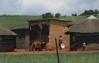
It's a spectacular half-day hike between the two. Since you're passing through a traditional Zulu kraal (one of the last genuine Zulu beehive umuzi and a major landmark for hikers), you might as well learn something about who's who and what's what in this neck of the woods (the following information was supplied by Meridy Pfotenhauer of Bergwatch). As already stated the amaNgwane nkosi of the area is Maswazi Hlongwane (there's a Hlongwane's Kraal just north of Makhela's).
The area of the Mnweni Valley is called Mabhulesini; the Ntonjelana area is Khokhwane; the area bordering Royal Natal National Park (Ifidi area) is inhabited by the amaZizi peoples and it's called Manzana; that bordering on Cathedral to the south is Ingoba.