
Uneven Sea Levels
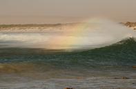
As human actions over the past 300 years have caused global air and sea temperatures to rise, and changed the world’s climate, our oceans have become a greater potential risk for three reasons: As the ocean warms, it swells, making the sea level rise. As ice over land masses in places like Greenland and Antarctica melts, it adds more water to the ocean, which causes the sea level to rise further. As storms become fiercer, the coastline takes a greater pounding. This is particularly severe when intense storms coincide with ‘spring’ tides, when the natural high tide peaks. One short storm surge can leave devastation in its wake.
The science is clear: change is already taking place and more is coming, even if we drastically reduce greenhouse gas emissions globally. But what makes preparing for that change so difficult, is the uncertainty.
Sea levels don’t rise evenly. Though stormier seas are a certainty, when they will come and where they will strike is hard to predict. Sea level rise is the ‘super tanker’ of climate change: even if we stopped atmospheric warming immediately, the oceans would continue to heat and expand for more than a hundred years.
Critical Questions
Expanding oceans are difficult to reverse in the medium term and are going to be a feature of life in coastal cities over the next century and beyond. Thus, this is a critical question: what level of risk is acceptable, and to whom?
How society grapples with these issues, often comes down to who will have to pay for the damages incurred by a rising or stormier sea. Similarly we must consider what advantages are gained by being positioned in a particular area, relative to being somewhere else that may be safer.
What the impacts of climate change and sea level rise will be for the coastal zone depends on many things: how much of the natural space is still intact and ecologically healthy; how much development has taken place and how exposed it is; how ‘valuable’ that space is in terms of its natural function or the development opportunities it provides to a community. The consequences will be measured in many ways:
Financial: Existing buildings and infrastructure will need constant repairs and reinforcing against the pounding they will take; insurance payouts may result in increased premiums or insurance companies may refuse to insure high-risk buildings; hidden, indirect costs of disrupted transport, decreases in tourism, loss of real estate values and reduced fishing opportunities from small harbours.
Recreational: The loss of amenities that attract people to Cape Town, and the need to create new recreational spaces.
Infrastructure: Key transport infrastructure is at risk from flooding and damage, including the False Bay railway line, the peninsula’s ports and small harbours, roads, bus and cycle lanes, and parking facilities, particularly in Milnerton and Strand, for instance.
Heritage: Traditionally, communities use the sea for fishing, religious ceremonies, and recreation on beaches and at river mouths.
Biological: Shifting fish habitats and changing ocean temperatures and acidity will alter marine populations, favouring some species and proving catastrophic for others.
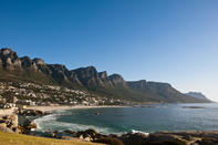
The Hot Spots
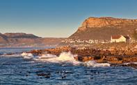
Each stretch of coast is exposed to the risks of a more aggressive sea for different reasons. Researchers and the City have identified 23 ‘hot spots’, including: Milnerton Beach, Saltriver, Green Point, Sea Point, Bakoven Cottages, Camps Bay, Kalk Bay, Strandfontein Road, and Strand. The Atlantic seaboard is at risk due to big wave events from the south-west while False Bay’s beaches and dunes are likely to face heavy erosion.