
Scenic Mountain Range
Soutpansberg is an enigmatic and beautiful mountain range that extends from east to west across the otherwise flat plains in Limpopo. It is named for the salt pan located at its western end.

The western section of the Soutpansberg range spans over 30 kilometres in width in some areas and features a fertile, well-watered plateau receiving high rainfall and supporting a wide range of crops and cultivated lands. But, with an annual rainfall approaching 3500 millimeters, it is the second wettest place in South Africa, and that means lots of lush vegetation and the animals that will naturally follow.
The area also boasts many historical sites, from the relics of the Stone Age San and their inimitable rock artwork, to the marks left by the ancestors of the Venda, and the tracks of the Voortrekker wagons that carried European migrants into an unknown land. Much of the area is maintained as a conservation area.
Important Rivers
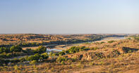
Crossing the Soutpansberg mountain range, you’ll find the all-encompassing plains of the Limpopo Valley, which stretches across the north of the country, characterised by further glimpses of the giant baobab and recurrent mopane trees.
Through this natural basin flows the Limpopo River, the country’s third most important river and a life source for the essentially hot, dry land through which it winds. It gives life to more than 500 tree species, a series of farming villages and one of the world’s highest concentrations of leopard. Another important river to the region is the Nzhelele, which flows from its source on the eastern slopes of the Soutpansberg to slice its way into the Limpopo just east of Musina.