
Behind the Rockeries
In Barrier of Spears, Reg Pearse says this pass is little more than a 'wild jumble of rocks and stones, in places very steep'. He concludes the section saying it is little used 'these days' on account of its difficulty.
Strange that, for it is now the favoured of the two passes going up to the Ncedamabutho (Mponjwane) headland, and both shorter and easier than Mnweni Pass. For sheer grandeur it's pretty much Mnweni's equal though, even if it lacks some of the more Gothic sculptures of the latter.
Ntonjelana River - Oozing Waters
From the visitors' centre keep well left to head due south up the right-hand bank of the Ntonjelana River. The name of the river means 'oozing waters' and it could apply to the whole of this region. For the next 5 km the path rises only about 100 metres, but it also comes back to the river only once on this stretch, after about 1.7 kilometres.
The conical hill on your left is Maxhozo or Scramble Kop, the very end of the main ridge coming down from the Cathedral range. This ridge is the southern boundary of the Mnweni area. Directly up ahead, looking over Makhela's Kraal, is the Saddle with the North and South Peaks creating an obvious landmark.
At the 5 km mark, about 600 metres below Makhela's Kraal, the Ntonjelan' ephumalanga and Ntonjelan' eshonalanga meet. Your path crosses Ntonjelana of the west and proceeds up the centre of the spur which comes down from the Saddle South Peak to Makhela's Kraal. About 120 metres above (and 1.5 kilometres in distance) the Ntonjelana confluence, the path splits round the spur into the two Ntonjelana valleys.
Our route is to the right, the eshonalanga. Below Makhela's Kraal an alternative path does lead from near the confluence up the eshonalanga, but then you'll miss the kraal (maybe this is the better option if you're not sure of your best Zulu manners). From the fork your path follows the contour along the South peak ridge, as it makes diagonally for the river which is crossed after about 1.4 kilometres, then climbs briefly and meets another path coming up the right-hand bank.
Turn left and upriver here. Depending on how you're feeling at this stage, this is an option for an overnight stop, for you're only halfway and the hard half awaits you.
Now The Real Work Begins
You'll be looking straight up the nose of the ridge coming down from the Saddle North Peak. After proceeding a short way up the bank to your right, the path crosses the river - on a hot day you might want to take a dip here because now the real work begins: you won't see the river again for the next 5.5 kilometres, but instead have to carry your load up that ridge.
For the first 240 metres the path zigzags up the front of the spur, then moves across to the left-hand slope. Take heart, because the next 170 metres is very steep and straight up, but take it slow and it won't hurt as much. In fact, so long as there is daylight you should make a point of taking all steep sections slowly.
There is often the urge to push yourself when the going is hard, and of course you still have to displace your total mass however many metres upwards. However, the speed at which you do it will determine how much you enjoy the gravity- defying act, or not. If you have to push time, rather do so on the less-steep sections.
Changing Views Are Stunning
Once you've crested the ridge and are going diagonally back towards the river, with the Rockeries dead ahead, it's almost flat for the next 1.5 kilometres to Scaly Cave, which is usually the overnight stop of choice for ascents of Rockeries Pass. Water is a long way away, but there's no other suitable place to camp nearby.
It's about 800 metres along and 80 metres up to the river, and this is the only tricky part of the pass, where you have to cross the stream coming down from Nguza Pass (a difficult rock climb) on the left. It's steep and difficult, but luckily short (Pearse's 'wild jumble of rocks and stones'). From where the Nguza Stream is crossed, there is still another 800-metre stretch to climb, crossing many side streams up the left-hand bank of the river virtually to the top of the pass.
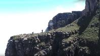
There are some steep sections along the way, but the changing views as you proceed up behind the Rockeries are stunning. The fluted spires are named A to G, starting from the outside 'shoulder'.
Camp Out In The Open
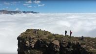
Topping out on the Ncedamabutho headland, with Mponjwane Ntabamabutho over the high ground on your right, one path leads off to the left for four kilometres to a waterfall on the Senqu, while another goes in a wide arc to your right to reach the top of Mnweni Pass, which actually lies straight ahead. If the weather's good it would be great to camp out in the open here, as water is abundant.
However, there are two caves - Ledger's or Mponjwane. Both are found over the lip of the Escarpment: Ledger's about two kilometres but with only a gentle climb to the north-east (its approach is marked by a cairn) and Mponjwane about half that distance but over steep ground to the sharp right (north).
By David Bristow