Hit the Railway
From town hit the railway and follow it west as it gets squeezed between the N5 on your left and Wilge River on your right. Where the line turns right (NW) you can pick up a nice farm road on the N side of the railway, lined with gum trees, although it does not run exactly parallel to the line.

There are quite a few wetlands and pans along these flatlands, which gives it a prettier aspect than would otherwise be the case.The line crosses the Wilge twice, by way of attractive arched bridges where you might have to pundamatenga (pick up and carry), but you can ride alongside the track in-between.
About 3 km from the second bridge the railway follows a gravel road and you can follow either as you please (where the road runs N of the line). Either way, about 12 km further you have to leave the railway and take the second of two gravel roads to the left (S) – the Elands River runs between them so you can't go wrong: the railway goes under the first road, over the river on a post-and-lintel type bridge and over the second road.
You turn left here and follow the S245 for 15 km to the tarred R57 where you turn left (S), the road follows a stream for the first 4 km, then through cultivated lands for the rest. At the tarred road you turn left and pretty little Kestell is 5.5 km further.
From the Caterpillar
Best you get in a good breakfast for this one, for while it's not very long, it is severe and will take most of the day. You start off up the track behind the cottages, and ride up and past a holiday fishing cabin on a small dam passing through (and closing behind you), a few stock gates. Then you swing to the right and the fun of the day begins.
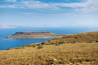
The first half of the route follows the S and SW shore of the Sterkfontein Lake (technically speaking, the ‘dam’ is the wall), not close but always high above. There are mostly paths, sometimes not, but even where there are the ground is extremely broken, often marshy and always hard to ride.
Twice you have to go through or over game fences or gates, but the upside is that you are quite likely to see eland around here. There is a 4x4 track closer to the water, but it does not go our way. At times the path, where there is one, goes up quite close to the sandstone cliffs on the left, and here the terrain is very rough.
Where the track comes to a small farm and it feels like Phuthaditjhaba is just a hop and a skip over the ridge, you have to take the road N to continue along the lake shore on a roller-coaster profile. You eventually pick up a tarred road and then swing away from the lake, first through farmlands and eventually into the peri-urban/semi-rural outskirts of the capital of Qwa-Qwa, previously known as Witzieshoek. Watch out for taxis, and ride on the sidewalk where you can.
The Perfect Route
One final word on routing: if you do go via Kestell, you will probably want to make the route from there, via Phuthaditjhaba to Napo village in Lesotho in one push of about 65 km - otherwise it will be one day of just 30 easy km to Qwa-Qwa, and another of 35 more challenging km to Napo.
A preferred route would take from Elandslaagte up Collings Pass, to Harrismith or Swinburne, depending. This would make for about one tough 90 km day, or one 30 km and one 60 km day The overnight stop on the ham option would be at Waterfall farm cottage, just a short way off the Collings Pass route.
Discovery: there is no short-cut around the S side of Sterkfontein Dam to Phuthaditjhaba, our gateway into NE Lesotho. But it took 6 hours of hard slog – really hard slog – to work that out. Problem is, the N side had far too much tar for our liking. The better option might well have been to go from Collings Pass via Harrismith and Kestell, as per our suggested routes.
 Starting from Elandslaagte there are two possible places to aim for: Swinburne and Harrismith. There is also the option of breaking the jour...
 For any mountain biking (MTB) enthusiast, South Africa is a magnificent treasure trove of trails waiting to be explored by avid crankers rea...