
Mnweni Valley
This is one of the longer, tougher passes to hike in the Berg, but amazingly it is fairly popular. One reason is the pure grandeur of the place, as well as the beauty of the valley.
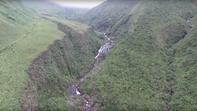
Then there’s the convenient location of Shepherd's Cave, 15 kilometres away and where the path starts its serious climbing into the Little Berg. If I had to choose just one hike that showcased the Drakensberg's mighty appeal, it would have to be this one, or perhaps its twin, Rockeries Pass. Since most routes here will go up one and down the other, you're in for thing awesome, so buckle up and take a deep breath. Up Mnweni and down Rockeries, or vice versa, should take four days, although it can be done on the trot in three.
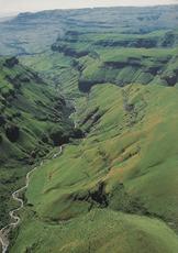
Down to the Mnweni Confluence
You're going to want an early start, so overnighting at the visitors' centre is suggested (remember to fill In the mountain register because, if ever you need to be rescued, this is the most likely place to start looking.) From the visitors' centre the path heads towards the Mnweni River (the right-hand fork), which it reaches after 1.5 kilometres.
But do not cross here, that path goes up towards Icidi/lfidi; rather bear left up the left-hand river bank. The path keeps away from the river and heads up the slopes on the left towards some kraals about 2.5 kilometres away: at first this seems inexplicable, especially when you start climbing steeply up a twisting path, but to quote my hiking buddy Adrian, 'the path always knows best'.
At one point you'll be at least one kilometre away from and 200 metres above the river, but don't panic. After about another two kilometres from the start you round a large spur (the one coming down from the Outer Mnweni Needle) and look straight down to the Mnweni/lfidi confluence. Amazing as it might at first seem, the Mnweni River here lies on a south-west/north-east axis and our path swings from north to south-east.
The Mnweni Baths lie below you somewhere. The path climbs and falls a few times along this section, sometimes as much as 120 metres at a time. At one point it comes really close to the river, but with a steep drop-off. Then it heads well away from the river. At 10.5 kilometres from the start the path splits.
Sleep Well - You'll Need It
You have to turn sharp left here to climb about 100 metres straight up the lower slopes of the Dassie (Mbazibalethe). This is the ridge that comes down from Ncedamabutho, with Mponjwane and the Needles to the left, divided by a deep valley. Now, if it hasn't hit you yet, you are getting yourself into serious mountains.
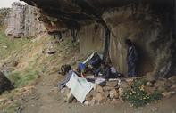
Awesome. And yet for the next 4 km the path keeps as close to the 1 700-metres contour as Thomas Bain could have engineered it — until you reach the Mnweni/Mbundini confluence. The path crosses just below the confluence, then has to cross the Mbundini coming in from the right. You're now on the right-hand bank of the Mnweni, and the headland 100 metres up on your right facing the river is important, for at the bottom of the rock band you'll find Shepherd's cave.
It's a medium sized shelter which can comfortably sleep around eight people. It's also a heavily used cave, so you should be prepared to share it with others. This is the meeting point of four passes (Mnweni, Rwanqa, Fangs and Mbundini). This is the recommended overnight spot. Sleep well; you'll need it.
There are other caves in the area which hikers use, such as Five Star Cave, but Berg aficionado Greig Stewart says there's also a great camp site among the trees and bushes near the Mnweni/Mbundini confluence.
It Gets Mercilessly Steep
About 600 metres from Shepherd's Cave the path, now entering the sacred nave of the Mnweni Cutback and climbing steadily, crosses a side stream coming down from directly in front of the Black and Tan Wall. I say 'sacred' advisedly: somewhere up on the right is Mbundini Abbey and Madonna and her Worshippers, straight ahead are the Twelve Apostles, and way over to the left is the original Cathedral Peak (Mponjwane).
You are in the heart of a natural Gothic cathedral, complete with spires, towers, fantastical gargoyles, and aerial colonnades. From the crossing it's a hard 2.5-kilometre slog up the right-hand bank of the upper Mnweni, to reach 'Chichi' Bush Camp. This is a lazy anglicisation of the Zulu name for ouhout, intshishi (Leucosidea sericea).
This site was an often used overnight spot, but is less so nowadays. The supposed camp site is actually above where our Path crosses the Mnweni to head up a side gully at a right angle to the main river. The going's been tough up to here, but from now it gets mercilessly steep.
That's why all about you the mountainscapes are so sublime: you are now in the cathedral's apse - the focal point of the Mnweni Cutback, where one would find the altar in a church and where the finest sculpture of our Gothic artist can be viewed.
In Ye Olde Days
In ye olde days mountaineers tended to head for Mponjwane Cave, way up on the other (south) side of Ncedemabutho, a 2-kilometre slog up from the top of the pass, because of the view I suppose. Or maybe they were just tougher and more senseless in those days.
But I much prefer Ledger's Cave, tucked a little up and over the Escarpment, overlooking the Mnweni Valley and with as dramatic views as any. It's a little tricky locating the vague path over the lip to the cave, and not to be attempted in mist unless you know the way. It involves a short scramble down and to the left. For 'Kodak' sunrises, it's hard to beat.
Alternatively you can camp in the bowl anywhere between the tops of Mnweni and Rockeries passes, which are separated by a 2.5-kilometre-wide promontory. However, this area is the source of the Senqu (Orange) and becomes a veritable bogland in summer. The pinpoint source is a shallow vlei back from Ledger's Cave where the tip of Mponjwane is just visible.
By David Bristow