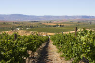
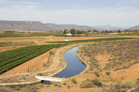
The Matzikama area in the arid northern part of the Western Cape has been inhabited for centuries by Khoi and San people, whose rock paintings can be seen in the Matzikamma Mountains. Farmers settled in this dry area in the 1730s and used the water from the Olifants River to start small vegetable gardens and water their livestock.

Agriculture, forestry and fishing contribute about 22% to the economy of the Matzikama municipal area followed by trade, catering and accommodation 17% and the manufacturing industry 14%. Mining and quarrying are also important employers in the area. Towns in the area include Vredendal, Klawer, Vanrhynsdorp and Lutzville.
Today Matzikama has grown to become an important agricultural sector in the Western Cape, supplying vegetables, raisins, wine, table grapes, processed products and other fruit, while aquaculture, especially abalone farming on the Matzikama coast at Doringbaai, is increasing. Agri-tourism in Matzikama is growing as more visitors appreciate the wine culture and seasonal flowers of the area.
Where is Matzikama?

The Matzikama district in the Western Cape falls in the West Coast District Municipality and is the most northern of the local municipalities in the Western Cape. The area of more than 5 000 km2 lies between the N7 freeway northwards and the Atlantic Ocean and is about 240 km north of Cape Town.
The Atlantic Ocean forms its western border while the Northern Cape forms the border to the north and east. The name means ‘place of water’, yet the area is characterised by an arid environment. The Olifants River and the 260 km irrigation canal together with its side channels from the Bulshoek Dam, supply water to the region.
It is along these waterways where most of the residents of this area are concentrated. According to the 2011 census, the population density of the Matzikama municipal area is five people per km2 with about 70% of Matzikama residents living in the urban centres of the region.
By Marinda Louw