
Bapedi-Boer Wars
Around five centuries ago, Sotho-speaking people drifted down from around the Great Lakes of Central Africa. The last of them, the Hurutse, settled in a mountainous area of what is now the west-central Limpopo Province: Sekhukhuneland, its eastern border the Steelpoort River.
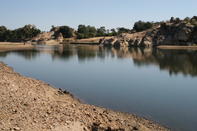
From them the Bapedi people descended. No sooner had these North Sotho people re-established their Iron-Age culture after the ravages of the Mfecane turmoil of the early 1800s, than land-hungry Voortrekkers arrived in the late 1830s.
There was constant bickering between the two groups: land grabbing followed by cattle theft, around and around. In 1861, Sekhukhune, 'a hard and cruel man’, became chief and set about arming his people with muskets and preparing for war.
The Boers had had enough of the troublesome Bapedi and, on 16 May 1876, they went to war against them. There were many ambushes, attacks on forts, cattle stealing and skirmishes, but never any one decisive battle. However, the Boers harassed the Bapedi and prevented them from planting their crops, so forcing Sekhukhune to eventually surrender in February 1877.
Orrie Baragwanath Pass
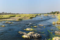
Louis Trichardt was sick of the tsetse flies around Soutpansberg and decided to head his wagon train towards Delagoa Bay. But two major obstacles stood in their way: the Drakensberg Escarpment and the Lepelle (Olifants) River. Five days of heaving wagons and arguing saw them cross the swollen river 13 times, until Louis said, “Bugger this, manne, we're going straight over those verdomde mountains” (or something like that - 'straight' being a relative term).
To get onto his route, start in Mokopane (Potgietersrus) and head east past Zebediela Citrus Estate. Just short of crossing the Lepelle turn left (north) onto the Orrie Baragwanath Pass, which will take you up the mountains and through The Downs rugged highlands area that is seldom visited these days.
It then descends via the Lekgalameetse Nature Reserve before reaching Ofcolaco and Trichardtsdal at the base of the mountains. For reasons known only to some 'planners' in a faraway town, from its summit to its western base the track suddenly becomes a super highway.
Wolkberg Wander
The thing is, Louis Trichardt did not actually go by way of Mokopane (Potgietersrus). His route from Soutpansberg did not go down Magoebaskloof Pass either, because there was no pass; there was, however, the biggest forest in the biggest kloof north of the Garden Route.
They headed instead up towards Serala Peak on top of the Wolkberg before plunging down into the Mohlapitse River Valley, on what is even now a rough 4x4 track. It will be easy for you to cross the river some 18 times as you go along, but imagine just how hard it was for them.