
History of the Pass
Houw Hoek is a close counterpart of Sir Lowry’s Pass. Where Sir Lowry’s lifts the traveller up onto the high mountain plateau, the Houw Hoek takes them down again to the coastal plain, and into the Overberg.
That much is simple enough, but the history of the pass is quite complicated. The name ‘Houw Hoek’ is of uncertain origin and varied spelling. Either transcribed as ‘Hou’ as in ‘hold’, ‘Houw’ as in ‘rest’ or even ‘Hout’ as in wood, this is a pass with many manifestations.
The first route over the mountains at this end of the chain simply went straight up to the summit, and steeply down the other side.
This was common practise in the days of the ox-wagon, as a span of oxen has more power when pulling in a straight line than when trying to negotiate a sharp bend in the road. Many of the old passes therefore eschewed all that gentle winding through the contour lines, and went for the straight up/straight down approach instead.
A Makeshift Affair
The first Houw Hoek Pass proceeded in this manner, up from the Houw Hoek Inn and down to the Bot (Butter) River. It was, by all contemporary accounts, a hideous passage that was even more dangerous than the formidable Hottentots Holland Kloof. Various stories of runaway wagons careening down the steep pass have been recorded, and many early travellers were heard to say a prayer of thanks when the traverse was over.
Charles Michell, the engineer, tried to complete the work he had started with Sir Lowry’s Pass by building a more sophisticated Houw Hoek road in 1831.
But Michell and his governor, Sir Lowry Cole, were still smarting from the rebuke they received from the Colonial office for the unapproved expense incurred by the building of Sir Lowry’s Pass the previous year, and the new Houw Hoek road was a pretty makeshift affair.
Pieces of the Puzzle
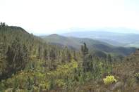
Michell’s road was eventually improved by Andrew Geddes Bain in 1846, and several other routes down the slopes seem to have been improvised over the years. None of these seem to have been entirely satisfactory, however, and each track was subsequently abandoned and swallowed up by the Fynbos.
At one point a fire swept the Houw Hoek summit and revealed the fossils of no less than 4 different routes. This only added to the confusion, but road historians are having a ball, trying to put the pieces of the puzzle together again.
Around the time of the Anglo-Boer War, a different route across the mountains was added to Houw Hoek passage.
Rather than going over the mountains, this route went around them, following the path of the Poespas River Valley. Poespas, by the way, means ‘higgledy-piggeldy’ and does not, as I originally thought, refer to a tight fit.
Find Your Own Way
The lower reaches of the Poespas River Valley had already been used by the railway line, but this alternative road was cut into the slopes above the train tracks by British soldiers.
This gravel ‘Railway Pass’ can still be followed by a car, if you are brave, but it is narrow, rocky and isolated; stuck halfway up the mountains, with the highway above and the railway below.
The road is also unmarked, and you will have to find your own way into the pass, which starts at the small sign for Koffie Kraal.
A Lonely Track
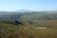
In the 1930s the Anglo-Boer War Road was abandoned and a new road, the most recent Houw Hoek Pass, was built to modern specifications over the summit. In the 1970s, this road was expanded into the current four-lane freeway that we drive today.
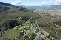
From the top of the pass, the view down into the Overberg is lovely, and the road quickly swoops along the contours, bringing us back to the coastal shelf on the other side of the Hottentots Holland Mountains. The first major hurdle in the Great Eastern Road has been surmounted.
By David Fleminger Elgin Valley is an outdoor paradise, situated between Groenland and Kogelberg in the Western Cape. Its commercial centre is the town of Grab...
 Grabouw is a farming area in the Overberg region of the Western Cape. It is surrounded by the Hottentots Holland and Groenland mountains to ...