
Sir Lowry’s Pass
British governor Sir Lowry Cole arrived in the Cape Colony in 1828 and stayed until 1833. Cole saw that the colony could not develop without proper access roads, and recognised the importance of the Hottentots Holland pass. He then ordered his chief engineer, Charles Michell, to improve the terrible track over the kloof.
The new ‘Sir Lowry’s Pass’ was opened in 1830. Sir Lowry’s was an instant success with the locals, but the road caused controversy with the colonial authorities back in England.
Evidently, the governor had given the go-ahead to build the pass without first asking permission from his masters in London. The colonial office responded with a sharp slap on the wrists, and Sir Lowry was censured for his insubordination. No further mountain passes were built by British authorities in the Cape in 12 years.
Hottentots Holland Kloof Pass
The first ‘road’ that was developed over the Hottentots Holland Mountain was known as the Gantouw route. It was used by government officials who had business with the Khoikhoi chiefs on the other side of the mountains.
Then, intrepid explorers, scientists and freebooters started climbing the Gantouw, looking for adventure and riches in the mysterious interior. By this time, the little cleft in the mountain peaks was called Hottentots Holland Kloof, and the pass was named accordingly.
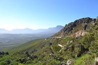
The view from the top of the pass is outstanding, and it’s worth stopping at the large viewing area for a quick look. Standing on the summit, buffeted by the wind, you can look out over the whole False Bay coast, from Gordon’s Bay right across to the mountains at Cape Point.
It’s a gorgeous sight, especially when the sun hangs low in the sky, sending a slanting ray of silver light across the deceptively tranquil waters of the Bay.
When you get there, be prepared for a howling wind in summer, as the South-Easter comes roaring around the Hottentots Holland mountains before gusting across the Bay towards Cape Town.
Historical OX Wagon Trail
The OX wagon trail was an important route that had serviced 4500 wagons annually by 1821. It should be noted, however, that 20 percent of these wagons were damaged by the journey.
The alternative route Sir Lowry’s Pass remained open throughout the years and continued to ferry wagons over the mountains in relative comfort and safety for over a century. In the 1930’s, the original cutting became too congested for the mounting traffic volumes, and the pass was widened and tarred. In the 1950’s, further improvements were made to the upper reaches of the pass.
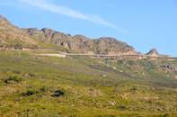
By 1984, traffic had become so heavy that a narrow two-lane stretch, close to the summit, had to be expanded. This was easier said than done as there was simply no more rock on which to build.
The solution was to construct a ‘bridge over nothing’ which transformed the pass into a grand 4-lane highway. It is now a well-used pass that motorists use every day to travel from the Cape Town area to other parts of the Western Cape.