
Early Inhabitants of Plettenberg
Matjes River Cave and Nelson Bay Cave were inhabited during the Middle Ages for well over 100 000 years. Bartolomeu Dias chartered the bay in 1487.
During the 15th century, Plettenberg Bay was named ‘the beautiful bay’ (Baia Formosa) by Portuguese navigator Manuel de Mesquita Ptrestrélo.
Ancestors of the Khoisan people possibly were the same individuals that traded with 100 Portuguese survivors of the Sao Goncalves shipwreck of 1630. They left behind the Van Plettenberg Stone. The first European settlers here from 1763 and were herders, frontiersmen and stock farmers. The year 1776 saw the bay serve as a barracks for the Dutch East India Company.
Development of the Bay
The Portuguese sea-farers who first landed on the shores of Plett called the place Bahia Formosa, meaning Beautiful Bay. And how right they were. It is a magnificent cove with wide, soft beaches and dreamy mountains wherever you look. The town’s name changed after the redoubtable Dutch governor, Joachim van Plettenberg, toured the region in 1778, and decided that it would be much better to re-christen the place after himself.
Initially, the Dutch had high hopes for Plettenberg Bay, but attempts to develop a harbour in the bay were unsuccessful. Instead, it was left to the British to develop the town, and one of George Rex’s descendants opened the first Inn in the 1820’s. This is now called the Formosa Inn, and some of the original buildings have been incorporated into the new structure. Plettenberg Bay was a stopping point during the 1830s for ships travelling to India during winter.
Edmund Roberts, a diplomat, noticed a large number of sheep and cattle at Plettenberg Bay as at 1833. He also made reference to the quality of butter from this town and the thriving local timber industry. The military barracks were converted into a rectory by St Peter’s Church in 1869.
Whaling closed down in 1916 when the whaling station on Beacon Island closed, yet sections of the iron slipway remain visible to this day. Plettenberg Bay became notably popular as a holiday resort from 1960, when the so-called Millionaire’s Row expanded rapidly.
Beacon Island
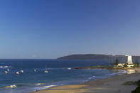
On the South side of the Plettenberg Bay is Beacon Island, so-named because the Dutch had installed a navigational beacon there in 1772. This piece of land was initially used as a whaling station, until a low-key hotel was built there in the 1940’s. In the early 1970’s, Sol Kerzner’s Southern Sun group bought the land and built a new hotel on the site, called the Beacon Isle.
This evergreen resort put Plettenberg on the map, as far as aspirational Vaalies were concerned, and the town has been growing ever since. So, once upon a time, Plettenberg Bay was a little town with a few holiday homes, one fancy hotel, the Piesang River caravan park and a magnificent beach.
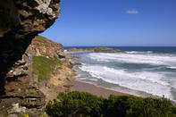
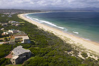
Thankfully, the beaches are still beautiful, and the Robberg Nature Reserve is a stirring reminder of how things used to look. Central Beach and Lookout Beach are the two main swimming beaches in Plett, and they are heart-wrenchingly lovely. Don’t miss out on a sunset walk along the sand, when the warm, diffuse light bathes the sea and drenches the bobbing fishing boats with a pink glow.
 Many guests staying at their accommodation in Plettenberg Bay spend the whole day on the terrace, with there being little incentive to mov...
 Bounded by Robberg Peninsula in the east and the Keurbooms River to the west, with the Outeniqua and Tsitsikamma Mountains as interior backd...