
Table Mountain Routes
There are literally hundreds of ascent routes up Table Mountain, ranging from the simple Platteklip and Nursery gorges, to climbs that are graded upwards of H (that is very serious rock climbing indeed).

Many of the old ascent routes have been closed off by the city's parks and forests department, due either to degradation or to their inherent danger. Others still, while they are known to the real mountain lovers, will not be revealed here; many are steep and prone to erosion so that excessive use would soon make them unpassable.
People who venture off the main paths on Table Mountain without a sound knowledge of the routes, should have their estates and wills put in order.
Local conservation authorities are wisely hesitant to develop hiking huts within the mountain reserve area, but it is to be believed that public pressure should be brought to bear on the various local authorities for the development of such facilities in suitable sites: at lower altitudes, or perhaps in or near forestry plantations.
Platteklip Gorge
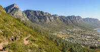
Distance: 10 km; Duration: 4 hours; Grade: Severe
If you do only one walk in Cape Town, this should be it. The route up Platteklip gorge is fairly strenuous, but then you are not really in a rush, and if Lady Anne Barnard could do it, so can you. If you get your timing right, you can do the whole climb in shade. Enjoy the knowledge that this route has been used by just about every famous person who climbed the mountain, from Admiral da Saldanha to General Jan Smuts (John Lennon went up by cable car).
Remember that every year hikers get lost or trapped here (usually through negligence), and some end up dead. Save yourself and the mountain rescue teams trouble, and go prepared: give the southeaster due consideration and, no matter what the weather conditions, take something warm to wear, preferably a lined windbreaker, and something to drink. Also, remember that the walk is linear, so transport will be needed to and from either end of the walk.
Skeleton Gorge
Duration: 1 hour (there); 45 mins (back); Grade: Moderate
This simple but exciting route up Table Mountain's forested, eastern flank was Jan Smuts' favourite walk. Although the route is hard to miss, the top of the gorge is blocked by boulders and, in wet conditions, with water gushing down, it may become dangerous. If the watercourse becomes impassable, it is possible to scramble out on the right-hand side of the gorge, but this too may be dangerous. Otherwise, it is a fairly steep but very beautiful hike. You will need to carry some money with you to pay the entrance fee to Kirstenbosch.
Silvermine Two Peaks Walk
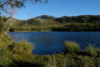
Distance: 9.5 kmilometres; Duration: 3 to 4 hours; Grade: Moderate
This walk provides access to some of the finest scenery in the Western Cape. Two summits, Noordhoekpiek and Constantiaberg are visited on the way, and the summit views from these peaks are the best in the peninsula. Constantiaberg is the prominent, rounded peak between Die Ou Kaapseweg and Constantianek, with the tall radio mast on its summit. Its central situation affords it the very best vantage point between Cape Town and Cape Point. A small entrance fee is charged at the Silvermine Nature Reserve, so take money with you.
To reach the start of the walk, take the Silvermine Nature Reserve entrance at the top of Die Ou Kaapseweg pass, then drive straight up the tarred road, and park at the parking lot near the reservoir.
Apostles' Traverse
Distance: 14.5 kmilometres; Duration: 5 to 6 hours; Grade: Moderate
This is a longish but fairly easy hike that is suitable even for a hot summer's day. There is, however, no water to be found on the hike, so carry according to the weather (in summer, preferably 2 litres for each adult). If you start from the upper cableway station, the walk becomes easier, but be sure you know the way or have a map, for even with signs it is easy to get lost on top of Table Mountain. Heat can quickly give way to cloud and rain, so you should be prepared for a change in the weather.
Cape of Good Hope
Distance: 12 km; Duration: 4 hours; Grade: Easy
This is an easy stroll along the scenic Cape Point coastline (get your permit at the entrance to the Cape of Good Hope Nature Reserve), where you experience a diversity of habitats from sandy to rocky shores, rock pools, headlands and cliffs. Anyone wanting more of a challenge can extend the walk by starting at Olifantsbospunt, near the Skaife Education Centre.
If you do decide on this longer variation, you will pass a shipwreck close to the centre. Baboons frequent this area, having become used to human 'handouts'. Avoid them totally, especially if you have food, as they can become a problem — even dangerous. You might also see bontebok, mountain zebra and eland. This is a linear walk, so take two cars for transportation.
 People who take the cable car up Table Mountain seldom get to see just how extensive the Back Table is. Indeed it is a veritable mountain wi...
 Because the satisfaction of walking up to the top of Table Mountain is so much more than taking the cable car, you have to walk up at least ...