
An Ideal Hike for Family Groups
Distance: 10 km; Duration: 2 to 3 hours; Grade: Moderate
The first section of this hike is along a broad path, on a gradual slope; it ends, however, up a steep rocky face that is negotiated with the help of a chain. Don't be put off, however, this hike is ideal for family groups. On full-moon evenings, this is an ideal place for a champagne picnic. Take lots of water with you on this walk, as the route is dry.
The walk starts at the steps at the top of Clifford Road (off High Level Road) in Sea Point. Climb the steps and you will emerge at a windbreak of eucalyptus trees. Walk up through the trees and take the path leading off to the right, then zigzag up Signal Hill. Keep to the most well-defined path or you will cause unnecessary and unsightly erosion - and get lost.
You will eventually come to a broad, near-level path, that leads to the gravel parking lot on top of Signal Hill. Just before reaching the top, take a short 10 m detour to a bench, from where you can admire the view of Sea Point and Robbeneiland. From the parking lot (you can drive here from Kloofnek), the Lion's Head path heads off in a southerly direction. The vegetation on Signal Hill is mostly grassy, so fynbos flowers are not much in evidence here.
Follow the path as it curves gently, ignore the junction a little way past the car park, and continue straight until a fence blocks your way. Do not cross the fence; instead, follow the path as it doubles back and gently climbs - the last 20 m of the climb are fairly steep.
Chain Ladder
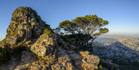
At the top of the slope you will reach another junction; turn left, in the direction of a tree jutting out from Lion's Head. The path is more or less level, having been cut into a reddish shale band.
Circle the lower slope of Lion's Head, until you find yourself looking down into the city bowl area. On reaching a wooden bench, take a rest before tackling the steep climb that awaits you.
A little way past the bench, you will see a chain hanging down from the cliff face above; climb it for about four metres. From here you may be confused as to where the route goes.
Continue straight up, aiming for a pine tree that sticks out above you. You will have to negotiate four ledges and short cliff faces in all, but you avoid the last one by using the chain ladder provided. On reaching the third cliff face, you will be rewarded with a grand view of Clifton, and Camps Bay.
From the top of the cliffs, it is a matter of a series of straightforward rock scrambles - follow your own route - to the top. If you have brought food with you, this is a wonderful spot to take a leisurely lunch.
Return the same way, or, at the first junction you meet on the 'up' path, go steeply down to avoid the main path's many meanderings. This latter route is steep and heavy on one's feet, and since it passes close to some precipitous drops, take extra care. You will join the main path about 150 metres above the car park.
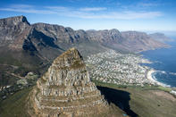
 Lying at the south-western tip of Africa, the Cape Peninsula is on the Atlantic side of South Africa. A spectacular view of the Cape Peninsu...
 The major reason for retaining the Western Cape mountains as pristine natural regions is that they are important water catchment areas in an...