
A Vast Sheet of Ice
The geological composition of the Drakensberg is fairly simple to comprehend it's the time scale that's difficult to grasp.
The escarpment and high peaks are the capping atop numerous horizontal layers of the Karoo Supergroup of rocks which cover some two-thirds of South Africa, much like the icing on a tiered wedding cake. (Another geological point you need to understand, and which geologists are slow to point out, is that the period when layer of minerals was deposited will not be the same as the one when a certain landform comprising those sediments, was formed.) The Karoo Period began about 250 million years ago (the earth is about four and a half billion years old) when the present continents of Africa, South America, Australia and Antarctica, as well as Madagascar and parts of the Middle East and India formed one super-continent that has been named Gondwanaland. Around this time present-day Southern Africa was covered by a vast sheet of ice.
When this continental glacier melted, it left behind a sludge of eroded material which solidified into the Dwyka Group lying in a basin that stretched from the south-western Cape to Mpumalanga and into Zimbabwe. This is the oldest and deepest layer of the Karoo Supergroup. The basin started off as an immense inland sea, and, as it filled up with further deposits and dried, the Ecca Group, containing vast forests of primitive trees, was laid down as mainly shales (these are the deposits which now yield our coal).
Then came the Beaufort Group, largest and deepest of all, comprising mudstones, sandstones and shales. Over the tens of millions years of the Beaufort Period conditions varied greatly but that era was characterised by swampy landscapes where the first amphibians crawled out of the Triassic seas to colonise the emerging land masses. They in turn evolved into mammal-like reptiles and later the earliest mammals.
Soft and Erosive Rocks
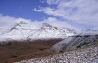
After about 30 million years of watery conditions the Karoo Basin filled up with sediments which in time became rocks. Dried out lakes become swamps and dry plains and then the wind-swept deserts of the Stormberg Group. It is the rocks of the Stormberg Group that make up the Drakensberg.
The first or lowest layer is the Molteno Beds comprising mainly blue-grey sandstones which form ledges and terraces at the base of the Little Berg. Plant fossils are abundant, but no animal remains have been found. The Red Beds form the second layer, with their typical red to purple mudstones and shales, which form the steep grassy slopes of the mid-Little Berg.
These rocks are seldom exposed in today's landscape, but the increased aridity which caused their deposition is thought to have brought about the slow demise of the mammal-like reptiles of the Karoo dynasty (not to be confused with the dinosaurs of the later Jurassic Period). Large, dinosaur-type fossils are abundant in this layer.
The large-grained, yellowish Cave Sandstone (or Clarens) layer appears to be largely aeolian (wind deposited). These rocks are extremely soft and erosive, which accounts for the cliffs that define the Little Berg, and the many caves and overhangs found in this very visible band of rock. Fossils are rare - mainly of reptiles and fish.
Lava-Covered KwaZulu-Natal
Towards the end of the Cave Sandstone time, Gondwanaland began to heave and buckle and split apart. What followed was a long period of wireworks: about 190 million years ago the land opened in huge cracks and fiery lava poured out to cover most of what today is KwaZulu-Natal, Lesotho and the Free State.
When solidified they formed the relatively soft, aerated basalt 'icing' on our mountain cake. With the break-up of super-continent Gondwanaland, continental uplifting and the climatic influence of the sea initiated a cycle of erosion which continues today.
What we see from below as the Drakensberg Mountains is really a giant step that is being continuously worn back by water and gravity. It is a mountain range that has no 'other side'; beyond our line of vision lies the mountain stronghold of Lesotho, the country which reputedly has the highest low point in the world.
When the last of the basalt covering has been chiselled away (at a rate of about one centimetre a decade) the soft sandstones and shales will soon be planed away by river erosion. During this time the climate will change, and so will the plants and animals. Then the area will likely look much as it did before the Stormberg period began - but just what creatures will inhabit the area is beyond our ken.