
The Original Shoreline
Before looking the retail wonderland that is the modern Victoria and Alfred Waterfront, one should go back a little and look at the original shoreline of Table Bay. When the Dutch landed at the Cape, the waters of Table Bay looked very different to today.
Back then, the sea came to within a few dozen meters of the Castle walls, and the original mooring for ships was at a little inlet called Roggebaai, located more or less at the end of today’s Heerengracht 'Gentleman’s Canal' Street. The original fresh water stream, suitably called the Fresh River, which the early ships used to replenish their water barrels used to enter the sea at this point.
The Fresh River now runs, unseen, through the storm drains under Adderley Street. At Roggebaai 'Rocky Bay', the big ships would sit at anchor, a short distance off-shore, while smaller boats ferried goods and people back and forth.
This wasn’t an ideal set-up, however, as strong winds and big waves often drove the bobbing fleets into the rocks. When this happened, the crew inevitably went to the nearest tavern and got wrecked a second time.
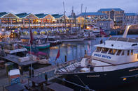
The Alfred Basin
The first part of the solution to anchoring at Rocky Bay was to build the Alfred Basin in 1860. Named after Queen Victoria’s second son, who was present to tip the first load of stone into the breakwater, this little man-made harbour was soon too small to handle the Cape’s increased shipping, and the larger Victoria Basin was soon commissioned.
In 1913, a lovely wooden pier and promenade was also established at the bottom of Adderley Street, but this was later demolished to make way for an even bigger harbour development, the Duncan Dock, which was commissioned during the second world war. While building the Duncan Dock, the harbour was dredged all the way down to it’s rocky bottom, and the huge volume of sand that they removed from the harbour was then dumped into the former Roggebaai inlet to create a large, level concourse.
This is the Foreshore, a rather barren strip of reclaimed land that runs South from the Castle towards the highway overpass and the modern harbour beyond.
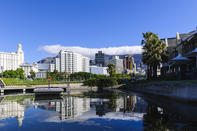
V&A Waterfront
When the larger-still Ben Schoeman Dock was built later in the 20th Century, the old Victoria and Alfred basins fell into disuse. The adjacent waterfront became a run down area of old warehouses, hobos and hookers. Then, in 1988, it was announced that the old V&A Waterfront was to be re-created as a multi-purpose venue with shopping malls, restaurants, yacht moorings, upmarket hotels, office blocks, apartment complexes, an aquarium and loads of other useful stuff.
Even the old Breakwater Prison complex was converted into the new University of Cape Town Business School campus. Thankfully, the new Waterfront development was carried out with sensitivity and style. Many of the old warehouse facades have been retained and converted into attractive shopping centres filled with jewellery, curios, clothes and coffee shops.
While it has its detractors, who deplore the rampant commercialism of the complex, the V&A Waterfront is an excellent place to stroll around. The Two Oceans Aquarium, an Imax Theatre and the Maritime Museum are all part of the complex, and it’s also the place where you catch the ferry to Robben Island.
By David Fleminger