
First Real Alpinists of the Berg
Route: From Monk's Cowl station via the Contour Path and Keith Bush Camp to the summit.
Distance: 38 km return
Duration: 10 to 12 hours each way (or 2 or 3 days)
Grade: Strenuous
General: The first known ascent of the pass was by David Gray and Major Grantham, who was doing a military survey of Natal in 1861 (and of Champagne Castle as well). However, the first recorded (official) ascent was by the Stocker brothers, the first real alpinists of the Berg, in 1888.
The first map of the mountains by real mountaineers was made by the Stocker brothers - an astonishing feat of exploration of what was then wild, savage, remote and near-inaccessible places. What few hikers nowadays probably realise is that they have Colonel AW Durnford and the 75th Regiment of the British Army to thank for the state of the passes. Following the Langalibalele 'rebellion’, they spent six months blowing up the access to many of the best passes in the Berg in an attempt to stop them being used by the local people.
It is written that they camped on David Gray's farm and attempted to 'destroy' Gray's Pass. They couldn't have been very good at it since these passes are still today used by hikers, Basotho traders, dagga smugglers and cattle rustlers. This pass is mostly a long walk, with some exposed traversing under the cliffs of Champagne Castle (maybe this is where the original pass was destroyed).
T-Junction Turn Left
From Monk's Cowl station, follow the routes up The Sphinx and towards Zulu Cave to Hlathikulu Nek: from the conservation office the path goes zigzagging steeply up the sandstone ‘head' directly behind the station, known as The Sphinx, for nearly 3 km. Once on top of this landmark, it's an easy 2.5 km walk up sloping grassland of the Little Berg plateau to reach the Contour Path at Blind Man's Corner at the base of Cathkin Peak/Mdedelelo.
Turn right here, winding in and out of shady stream gullies for 2.5 km to Hlathikulu Nek. This is a T-junction where you must turn left to keep the Amphlett (a continuation of Cathkin Ridge) on your left. For 1.5 km the path winds around two spurs of the Amphlett, to reach a four-way crossing on the Contour Path.
Gray's Pass
Straight ahead will take you down to cross the upper reaches of the eMhlawazini River on your way to Didima and Cathedral Peak; the lesser path to the right goes to Zulu Cave, but you must turn left here to follow the left-hand bank of the eMhlawanni for 3 km to Keith Bush Camp. The path up this section starts off easy enough but soon begins to climb somewhat more steeply and then crosses to the right-hand side of the river just below Keith Bush Camp.
In the late afternoon, when the cloud shrouding Monk's Cowl has dissipated in the cool evening air, the sun casts a warm copper glow onto the peak that otherwise stands secretly plotting in its dark recess. Most hikers use this spot as an overnight camp, as it's a good 12 km from the start, with a climb from 1 480 m at the start to 2 350 m here more than enough for one day for most hikers.
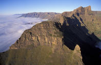
Gray's Pass begins just above the camp, keeping to the crest of a ridge rather than the stream gully on your right (the government 1:50 000 map shows the path going up the gully). This slope is highly susceptible to erosion, so take care not to leave the main, oft-repaired path. After about 1 km of steady climbing, you reach the main cliff base, and you'll need a long breather here.
The path swings to the right to traverse under the cliffs, while continuing to climb - albeit much less steeply - for 1.5 km. This is a spectacular section, although very exposed in places, and possibly wet; at one point you have to do a short scramble up, which can be strenuous with a loaded pack. Watch out along here for baboons, which forage about the slopes, as well as pretty blue bell-like heads of Wahlenbergia undulata that grow in the damper places.
To Find Nkosazana Cave
On nearing the last few hundred metres of the summit the path veers to the left up a gully that separates the top of the Dragon's Back from Champagne Castle, which rises in three steps to its highest point 2.5 km to the south (left). The gully is littered with large rocks and the path winds back and forth across it. You will now be looking across the Nkosazana River Valley, if you can see at all through the mist that often gathers here.
To find Nkosazana Cave, cross the river (which can be a boggy experience in summer) and head a few hundred metres upstream. The cave is located in a low rock band, about 150 m from the river and is marked by cairns (and, less welcoming, other people's waste after a long weekend). But, be warned, it is not a generous cave: in fact it's awful most of the time, and wet, even in winter, and sleeps four, sometimes only two people comfortably in wet conditions.
From the cave you can walk down the Nkosazana River (after the Zulu name for Monk's Cowl - Nkosana, the 'little chief', 'heir' or 'prince') for about 1 km, where the river makes shallow pools as it flows over rocky terraces and then plunges over the Escarpment.
Champagne Castle
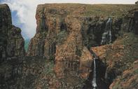
It falls in several dramatic leaps down a giant's staircase, named Vulture's Retreat because a colony of Cape vultures nests on the cliffs to the left of the waterfall. In winter the falls ice up and stand in great white columns, or hang as giant icicles. Counter-poised against the flaking basalt scales of the Dragon's Back, Nkosana is one of the finest spectacles of the High Drakensberg and seen only by those people who hike to the summit (or Air Force helicopter pilots who train here and have to land their choppers next to the falls - sorry vultures, our national security is at stake!).
It's a short, 2.5 km stroll up the Nkosazana Valley to the highest point in the area, Champagne Castle (3 248 m), one of many 'peaks' that at one time or another was thought to be the highest along the watershed; it is still sometimes claimed in pubs and around braais to be the highest (actually only number three on the list). I put 'peaks' in inverted commas for few high points on the Berg can really be classified as peaks. One current-day mountaineer has coined the term 'kulus' for the high points of the watershed, taken from the Zulu word for 'big'. The return route re-traces the ascent via Gray's Pass. You can make it a circular trip by reversing the more strenuous but also more spectacular Ship's Prow Pass.