
Toughest in the Berg
Route: From Monk's Cowl EKZNW station, via the Contour Path to the south, then up the Prow/Del'mhlwazini, River through Ship's Prow Pass.
Distance: 42 km return
Duration: 12 to 14 hours each way (or a 3-day return trip)
Grade: Extreme
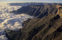
General: This alternate route up or down Champagne Castle is one of the toughest in the Berg, but is used more often than many easier ones because it is one of only two ways to the top of the most visited areas of the Drakensberg. On the other hand, if you're fit and can heft a backpack with ease, and are blessed with good weather, this also happens to be one of the most breathtaking routes to the summit. The 'prow' may look like just a little triangle on your hiking map, but it is a sharp, massive bow of rock that juts out of the Escarpment, cutting the clouds like a gargantuan ship cleaving the waves.
Storms and Mountains

The seas this ship steers can be stormy indeed. On Old Year's Day 1980, two young Free State men and a lady friend from Pretoria decided to go hiking for five days in the Berg. Their intended route in the mountain register was to 'walk up Cathkin Peak' which, in retrospect, showed they had little idea where they were going. On 2 January there was a tremendous storm which washed away roads all over the foothills.
They must have been caught on the summit, somewhere behind Champagne Castle (another party saw them on New Year's night in Nkosazana Cave), and anyone who has been caught in such a storm knows how terrifying they are. By the 10th they had not returned home and a helicopter rescue team was called in.
After a long search (given their pathetic route description in the mountain register) their remains were found in Ship's Prow Pass. At first, it was thought they had been caught in their tent camped next to the stream, but later the search-and-rescue leader Dr Sherman Ripley concluded they had been washed downstream while trying to cross the raging torrent that these streams become after a storm. Ripley called the boulder stream 'a torrential grinding machine' and, when the bodies and equipment were found, they were indeed ground to pulp.
Don't let this put you off Ship's Prow particularly, because it could have happened in many similar places. Every river in the Berg becomes dangerous when flooded, and this is by no means the only recorded death in flooded rivers in the Drakensberg. Take heed of the moral of the story and exercise great care with storms and their consequences (including lightning, which has also killed its fair share of people).
Ship's Prow Fork
From the conservation office follow the route up The Sphinx for 5.5 km to the Contour Path. This section should take about three and a half hours, because the first part up the inscrutable Sphinx is pretty tough for its mere 2 km haul. From there the path gently climbs up a grassy plateau towards Cathkin Peak, with the full sweep of peaks from Champagne Castle to the Amphlett in view. When you reach the contour at Blind Man's Corner, you must turn left.
From here you have a 10-km walk along the Contour Path. However, in spite of its being extraordinarily beautiful and as dramatic a stretch of hiking as you'll do anywhere in the world, it is also energy sapping and you'll be glad to reach Ship's Prow fork at the end of a solid day's walking of 15.5 km from the start.
As you walk along the Contour Path the direction changes as often as the slope (which, in places such as the head of Wonder Valley or where you have to cross over the long spur coming down from Monks Cowl 2 km from the Monk's fork campsite, is not on the contour at all) and new windows open on views looking up to the grand ramparts on one side and down to deep wooded valleys on the other.
The Vlei
A cartographic note of interest to hikers using this route is that the point reached 4 km after turning left along the Contour Path is not a second junction known as Blind Man's Corner, as it would appear to be on Slingsby's map, but is in fact called The Vlei. At this point you should be able to see a tarn about 200 m down the Little Berg plateau, along a path that leads down to Injisuthi and Wonder Valley Cave.
Also, a short distance ahead along the Contour Path is a fence designed to keep the small herds of eland which live in the Injisuthi area from wandering off down the Champagne Valley road to one of the hotels or to the Thokozisa tourist centre. You should aim to overnight where the Contour Path reaches Ship's Prow Stream (where this river meets Cowl Form Stream, it becomes the Del'mhlwazlnl River, a northern tributary of the Injisuthi River).
The pass itself is 4.5 km long, and then a little further to reach the point where you plan to stop. The first 3 km are not steep, as passes go, gaining 700 m along this section as you follow the stream's left-hand bank. Finally the stream splits around the Ship's Prow and you have to choose one of the forks: the left-hand one is easier but longer than the right-hand one. However, take great care as you decide as the right-hand approach is a boulder-strewn gully which in flash storms can become a bowling alley. If it looks even remotely as if heavy rain is on the way, take the left-hand fork.
The top-most section of the right-hand fork consists of treacherous scree and vertical rock, so before trying it you should be confident of your mountaineering skills.
Highest Pass of the Drakensberg
The reason for this pass's difficulty becomes clearer as you attempt to board the giant boat’s prow - it's just so high. In fact, it stands proud at 3 300 m and as such is the highest pass of the entire Drakensberg. From the Contour Path at 1 950 m you have to climb a whopping 1 350 m to gain the summit.
And then you have to walk either behind Champagne Castle and over into the Nkosazana Valley to the right (north) to a campsite, or down to a valley to the south in Lesotho. Nkosazana Cave is reached 3 km down the Nkosazana Valley, 100 m up from the left-hand bank of the river, going downstream. The easiest way down is via Gray's Pass, although Leslie's Pass 6 km in a straight line to the south will bring you down to Injisuthi camp via Junction Cave.