The South-Easterly Wind
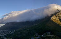
It is the famous South-Easter wind that causes the ‘tablecloth’ of clouds over Table Mountain. During summer, this prevailing wind howls through the streets of Cape Town, slamming car doors and flailing at the trees.

It is a hearty, gusty wind that can knock you off your feet once it really gets going, and locals affectionately call it the Cape Doctor. This is ostensibly because it blows all the pollution and sickness out of the city, but it also describes what you’ll need if you ever get hit by a fly-away tree branch.
How the South-Easter Works
In the summer months a belt of high-pressure cells, called anti-cyclones, move North over the oceans, nearing the Cape Peninsula. This weather system pumps air up towards the southern coast line, but this air gets trapped by the mountains which line the coast. As the pressure starts to builds up, the air is pushed along the mountains, looking for a release.
At Cape Hangklip, near Hermanus, all this ‘compressed’ air is suddenly let loose. It corners hard around the Hottentot’s Holland mountains at breakneck speeds and races out over the expanse of False Bay. As it travels over the sea, the hurtling South-Easter picks up lots of moisture. Then, it slams into the mountains of the Cape Peninsula.
Some of this moisture-laden air is subsequently pushed up the back of Table Mountain. This causes the air to cool as it rises and, when conditions are right, the water particles suspended in the air condense into a fine water vapour. This is what pours over the edge of the Table in a gracious billow of cloud, threatening to swamp the city below. But this doesn’t happen.
Even though the tablecloth tumbles over The Mountain in a thick plume, the water evaporates in the warmer air and it never reaches the city.
By David Fleminger