
Shape of the Peninsula
The Cape Peninsula is shaped like a claw, curving out into the sea between Table Bay and False Bay.
It is a magnificent headland, with extravagant mountains, dramatic seascapes and attractive suburbs all competing for your attention.
The main road around the Cape Peninsula runs from the City Bowl along the Atlantic Seaboard suburbs of Green Point, Sea Point, Clifton, Camps Bay, Llandudno, Hout Bay, Noordhoek and Kommetjie.
From here, the road veers inland to rejoin the sea on the False Bay side of the Peninsula.
You can now turn south towards Cape Point, or turn north and drive up the False Bay coast to Muizenberg.
From Muizenberg, you can either take the M3 highway or the robot-riddled Main Road (the M4) back to Cape Town, through the Southern Suburbs.
The round trip is about 150 km, including the detour to Cape Point.
Various Cape Peninsula Routes
One route starts at the edge of the Cape City Bowl as a humble thoroughfare, called Somerset Road. As Somerset Road curves around the foot of Signal Hill, it changes its name to Main Road, and leads through the high-rise suburbs of Green Point, Mouille Point and Sea Point.
After Sea Point, the road does a little dog’s leg and changes its name, once again, to Victoria Drive.
Also known as the M6, Victoria Drive then continues across the precarious cliffs of Clifton to the rarefied atmosphere to Camps Bay.
At Camps Bay, you can either follow signs for Kloof Nek, which will take you up to the Cable Car Station and then down to the Cape Town City Bowl.
Or you can continue with Victoria Drive, along the coast, to Llandudno. At this point, the road rises over a low nek between the Twelve Apostles and the Little Lion’s Head, and descends to Hout Bay.
Hout Bay is actually a very isolated settlement with only three land-based access routes: Constantia Nek (M63) to the Southern Suburbs; Victoria Drive to Camps Bay and Sea Point; and, the greatest of them all, Chapman’s Peak Drive (M6) to Noordhoek.
After Noordhoek, take the continuation of the M6 to Glencairn, a little town to the south of Fish Hoek. Or, continue on the road around the Cape Peninsula by taking the M65 west, to Kommetjie and Scarborough.
After Scarborough, the road turns away from the sea, and you can either take the spectacular Red Hill Drive down to Simon’s Town on the False Bay coast.
Or you can continue with the M65 towards land’s end at Cape Point.
Driving Along Main Road
The M4 starts at the southern corner of the Castle. Despite the antiquity of its origins, driving along Main Road today takes you on a fascinating journey right through the pulsing, bi-polar heart of modern-day Cape Town.
Initially, Main Road leads from the City Bowl, around the bulk of Devil’s Peak, through the crowded, honking streets of Woodstock, Observatory, Salt River and Mowbray.
Pedestrians, pots and pans, taxis, hawkers, general merchants, carpet sellers and pawn shops fill your eyes, while the beat from a sound system outside a shop (or even inside a car) offers a thumping bass as an aural counterpoint to the urban landscape.
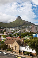
Then, the tenor of the road changes as it passes the very large Groote Schuur Hospital. This is the great medical institution where a slightly mad visionary named Dr. Christiaan Barnard, performed the world’s first heart transplant back in 1967.
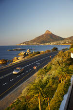
 Lying at the south-western tip of Africa, the Cape Peninsula is on the Atlantic side of South Africa. A spectacular view of the Cape Peninsu...