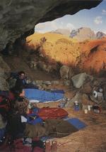
Official Overnight Cave

Route: From Monk's Cowl station up to the Contour Path, past Hlathikulu Nek and down the eMhlawazini Valley
Distance: 24 km
Duration: 10-hour round-trip (2 days)
Grade: Strenuous
General: This was a well-known and often used cave in the golden days of Berg exploration, but in the past few decades has been very much overlooked as it is on a culdesac. Perhaps now that it has been declared one of only a few official overnighting caves in the Monk's Cowl region (remember to book it), hikers will rediscover its charms.
Hug the Cathkin Ridge
Sign the mountain register at the gate, pay your money, then head past the office and to your left (signposted) and through a gate. Carry on to the top of The Sphinx. From the top of The Sphinx the path heads directly towards Cathkin Peak, heading slightly uphill through tall montane grassland. Once you reach this section of path you may find that your legs want to stretch out and you want to get closer to the big peaks as soon as possible.
About 2.5 km from Breakfast Stream, with Wonder Valley falling away to your right, you reach the Contour Path at Blind Man's Corner. Turn right here (left will take you either down into Wonder Valley and the Wonder Valley Cave, or further on to Injisuthi) along what could be the loveliest section of the Contour Path, as it offers really easy walking while you hug the Cathkin Ridge and all its peaks on your left
George Amphlett Peak
For 2.5 km you wind in and out of delightfully wooded stream gullies, some with pools, one with a small waterfall, to Hlathikulu Nek at the base of the Amphlett. The peak was named after George Amphlett, an early member of both the Mountain Club and even more select Alpine Club. He was typical of the climbers of his time, in that he was a pillar of society — general manager of Standard Bank — and was quiet and unassuming, according to Reg Pearse.
He was among the party that made the first ascent of Cathkin Peak (3 149 m) in 1912, and had this subsidiary peak (2 620 m) named after him to commemorate that and all his many other firsts in the Berg. At the Nek, continue to the left along the main Contour Path for 1.5 km to the junction where a path to the left up the upper eMhlawazini Valley to Keith Bush Camp (named after the ill-fated climber who fell to his death here in 1955 while abseiling off the north face of Cathkin Peak) joins the lower section of Gray's Pass that heads up 'behind' Cathkin Ridge (on the northern side).
Head Down the Spur
Here a lesser path turns off to the right, while the Contour Path heads downhill to cross the eMhlawazini on its way round Intunja and onto Didima. Take this path to the right, along a spur that is pushed out between two branches of the eMhlawazini. It is easy to lose the path, but what you are trying to do is head down the spur to where the two streams meet just 1.75 km from the Contour Path, then cross over to the left-hand bank of the eMhlawazini.
Continue downstream for just over 1 km, crossing one larger then one smaller side stream, as the path heads uphill and away from the river which hereabouts is flanked by fairly dense bush. Now the path veers to the left around a bulge, leading you up a side valley and towards the Little Berg plateau. After 500 m up this side gully you come to the cave right in the stream course, one of several grand shelters in the area which will comfortably sleep a large group, of up to 12.