
Tulbagh and Beyond
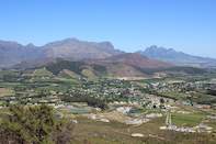
The historic winelands terminate in the north in the shadow of Groot Winterhoek Peak, around the town of Tulbagh, named in honour of the 18th-century governor, Ryk Tulbagh. It lies in the long valley between the Groot Winterhoek, the Hexrivier and the Witzenberg Mountain ranges, where the Berg River has cut its way out of the Western Cape's mountain vortex. From here to Stellenbosch, the winelands follow the curve of the Cape's Folded Ranges, painting the valleys green in spring, russet and gold in autumn.
In February the vines droop with bunches of pale-green hanepoot, riesling, and steen grapes, or glow with splashes of deep purple such as tart cabernet, cinsault, and pinot noir grapes. The curvilinear gables of the stately Cape Dutch homesteads which characterise the winelands echo the shapes of the rock buttresses which stand as dramatic backdrops to the estates, stark white moulding accentuated by the mute grey sentinels.
Breede River
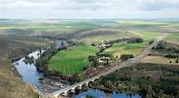
The headwaters of the Western Cape's principal waterway, the Breede River, rise on the gnarled slopes of the Hex River Mountains and Witzenberg Mountains, carving their way through the enclave of Ceres and the wide valley wherein Worcester stands, forcing their way between the Riviersonderend Mountains and the Langeberg, from Robertson to Swellendam, before wearily emerging on the wide coastal plain that stretches to Agulhas - the southern tip of Africa.
At Malgas Pont ferries aid cars and people in crossing the broad the lethargic river, where trees and a lonely cottage are reflected in the dappled waters. The Breede River breaches land at Infanta in St Sebastian Bay, where, in spring, southern right whales come to nurse their calves. These leviathans play in the calm waters of the southern Cape coast’s bays, leaping out of the water and smashing down again, their enormous flukes slapping the sea.
Swellendam to Cape Agulhas
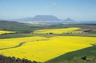
The wide coastal plain between Swellendam and Cape Agulhas is covered with fertile shale-derived soils and limestone, which give rise to quite different natural vegetation. The shales once supported dense expanses of coastal fynbos, but there is very little left of this flora. It has made way for wheat and canola fields that cover the land like a corduroy patchwork between Caledon and Riversdale.
The limestone surface to the south of Bredasdorp hails from the mid-Cretaceous and Tertiary periods (about 50 million years and less than 20 million years ago respectively) when the sea advanced and retreated across the wave-cut plain, depositing shells which decomposed to form calcium-rich soil.
Cape Super Rocks
Over the last few hundreds of millions of years the Cape Supergroup of rocks, which forms the region's mountain ranges, was buckled and twisted during the movements of continental plates. At one stage the highest peaks stood over six kilometres above sea level, and they have since been eroded until only their bases (composed of Table Mountain Sandstone) still show, resembling the worn-down stumps of the teeth of an ancient creature.
The Bokkeveld shales were deposited on top of the sandstones, but they are softer and so have been completely eroded away from the upthrust folds and remain only in the valleys, with layers of sandstone beneath them where the folds dip below the surface.