On the Kokerboom Food and Wine Route
Many tourists travel through Keimoes en-route to and from Gauteng and Cape Town, as well as those on the Kokerboom Food and Wine Route.Travellers are initially drawn by the Tierberg and the Water Wheel, but little do they realize that this lush green town in the semi desert consists of more than 120 islands – with people actually living on most of them!

Keimoes boasts a rich and lively history. When one uses some imagination, it is easy to picture the Korana Chiefs Klaas Lukas and Piet Rooi who used to hide with up to 10 000 stolen livestock on the island maze in the 19th century. That explains the apt name of one of the koppies – Loerberg. Directly translated this means “Mountain from where one can peep”.
Water Channels and Keimoes Islands

The completion of the first water channels in 1883 led to the rapid growth of the settlement. The first school opened in 1887, and the Mission Church and a mill were completed in 1889. Many battles were fought during the first and second Korana Wars with the government forces using canons with great success. Hence, other names like Kanoneiland and Skanskopeiland, meaning ‘Canon Island’ and ‘Barricade Hill Island’ respectively, came about. Coming and going on the island is dependent on the whims of the Orange River and its varying water levels.
One of the milestones in the history of Keimoes is the installation of a pont at Milldrift in 1907 and Rooikop Island in 1910. From early on grape farming was the backbone of agriculture in and around Keimoes. In the early 1900’s the town was known for its “Keimoes-blits” - an infamous liquor with an even more infamous kick – distilled from hanepoot and crystal grapes.
The Keimoes islands are linked by a network of suspension bridges. The pupils of Klip Island School have to cross such a bridge every day to get to class; quite a nerve-wracking experience when the river is in flood. At one stage, sixty of these bridges provided the necessary connection for farmers to bring their produce to the markets. If one takes into account that such a bridge can only bear 100 pounds of weight at one stage, it becomes clear that farming and transport of goods between the islands must have been no easy task. The first documented export of produce from Keimoes was for 2000 cases of oranges in 1927. Today, Keimoes is a prime source of table grapes exported to Europe.
Floods have been part of everyday life for the people of Keimoes. Most memorable were the floods of 1925, 1934, 1974 and 1988. The name “Keimoes” means “Big eye”. The two possible explanations given are that it refers to a permanent fountain near the Roman Catholic Mission station, or to the magnificent view of the area from Tierberg. The latter is more widely accepted. Keimoes forms part of the KaiGarip Municipality, which also includes the towns of Kakamas and Kenhardt.
Keimoes Attractions

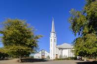
The Dutch Reformed Mission Church was built by Reverend Schröder in 1889.
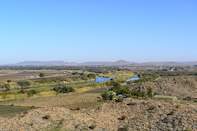
Tierberg Nature Reserve lies four kilometers from the town on the road to Augrabies Falls National Park. Teeming with springbok, it covers 160ha and is noted for its many aloes - mostly winter flowering. Spring sees many succulents in full flower. At the summit of the reserve, there is a lookout with a marvellous view across the Orange River Valley.
A reconstructed waterwheel operates on Main Road.
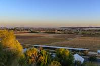
On the slopes of the Tier Mountain, you will enjoy wonderful views of the river’s islands and irrigation scheme.
 The Kokerboom Food and Wine Route embraces the towns and settlements of Keimoes, Kanoneiland, Kenhardt, Augrabies, Upington and Marchand. Th...