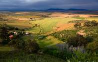
Wheat-producing Area
Swartland is a well-known wheat-producing area of the Western Cape, centred around the town of Malmesbury, stretching from Philadelphia in the south to Piketberg in the north.

In the east, the Swartland is bounded by the Winterhoek Mountains, Heuningberg and the Olifants River Mountains, while the dunes of the West Coast and the Groenkloof River form its western boundary.
This region is characterised by its gently undulating hills and rolling wheatfields, which account for about 20 percent of the country's wheat production.
Although the Dutch name 'het Zwartland', which means 'the black country', was first used in 1701, there are several interpretations of its origin. One of the more plausible is that the name refers to the colour of the once-plentiful renoster bush (Elytropappus rhinocerotis), which is black when wet. Its protection is therefore, possibly, a high priority in terms of South Africa’s biological conservation.
The main centres of the Swartland are Malmesbury, Moorreesburg, Piketberg and Porterville, as well as the Riebeek Valley. The Swartland Wine Route consists of several estates, co-operatives and cellars and one private cellar.
 Flower season in the Cape is something magical to behold - Experience the beauty of spring wild flowers on The Cape Flower Season Route....