
Orange River Road
Every worthy journey needs to have a purpose, or a theme, like of the Voortrekker routes, or a river. Following a watercourse by definition is challenging, and therefore very appealing, and trailing the River in particular has fascinated many travel adventurers.
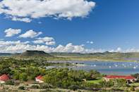
Start at the Gariep Dam and take the R369 to Hopetown, then follow a dirt road northwest from there to Douglas. From there, take the R357 southwest to Prieska (check out the tiger's eye fort), then head up the N10 via Marydale to Groblershoop until it meets the N14 at Upington. Now go southwest via Keimoes and Kakamas to the turnoff to Augrabies, where this journey ends and the next begins.
Kalahari Raptor Route
This touring route of another feather starts at Kuruman Kalahari Raptor Rehabilitation Centre. It then follows the Kuruman River, past Hotazel, to its confluence with the Molopo at Witdraai (these rivers run more sand than water, just in case your expectations were otherwise).
From there it meets the Namibian border before heading down to Upington, where it follows the Orange River to Prieska. In truth, this route is something of a tourism marketing construct to get you to visit some of these less popular holiday destinations. But hey, why not? The raptors are there and they're raving.
Route 27
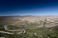
A fair bet would be to assume that as a South African, you used to sit and listen to the old radio weather reports and wonder just where those magical sounding Gordonia and Bushmanland places were, where it was always hot. The easiest way to find it in your atlas is to flip through the pages and stop at the spread that has the fewest roads and places.
The R27 road starts on the high Hantam Plateau of the Great Karoo and travels from Calvinia, via Brandvlei and Kenhardt, to Keimoes on the Orange River. On the way, the Karoo melts to endless saltpans and then to red Kalahari dunes. When you start seeing huge social weaver nests weighing down the oversized boughs of camel thorn trees, you will know you are nearing the 'great' river.
The Diamond Coast
The West Coast route is a doddle… until you move from the genteel Western Cape into the rough and rugged Northern Cape, that is. This is where you start to need all the horses and hooves your car can muster; you'll also need some deft navigational skills as you thread your sandy way north from the Olifants River mouth, if you want to do it properly anyway, avoiding the N7.
The only places where there really is anything are Hondeklipbaai, Kleinplasie and Port Nolloth. Then again, if you've never been to spoegrivier and seen the waterfall, or to Groenrivier and seen the flamingos, you've got a lot of seeing left to do. You may not keep any diamond you stumble across, however.