
Clearing a Path
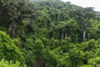
The Tsitsikamma Forests, lying between Plettenberg Bay and Humansdorp, were the thickest and the most forbidding in the entire Cape Colony. And, despite many attempts, the dense forests deflected any human attempts to penetrate their verdant violence. For years, the tangled roots, dark ravines, mighty rivers, towering trunks and clinging underbrush of the region stumped even the most determined of explorers.
In 1839, Charles Michell, chief engineer of the Cape Colony, went so far as to write ‘There is no practical way – not even a footpath – [to get from] from Plettenberg Bay to the Zitzikamma country’. But fate intervened when the Great Fire of 1869 thinned out the trees. This gave ambitious roadmakers a small window of opportunity to blaze a new trail through the thicket.
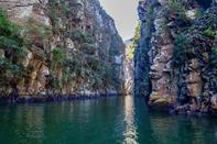
Accordingly, after planning his Passes Road from George to Knysna, Thomas Bain proceeded to scout out a path through the wooded wilderness from Knysna to Humansdorp. With many of the trees gone, he did not have to worry so much about clearing the path, but he was faced with another problem – conquering the steep river gorges that cleave through the land, from the foothills all the way down to the sea.
Undeterred, Bain plotted a winding course along each valley; down to the river and up again, down and up, just like with the Passes Road. It would be tortuous, tedious and slow work, but it could be done.
Tsitsikamma Gorges Road
Bain was a busy man, however, simultaneously building, planning and supervising roads all over the country. So, what with one thing and another, construction on the Tsitsikamma Road only began in 1879. It was finally completed six years later, in 1885. It was hard work, and three major gorges, the Groot River, Bloukrans and Storms River, had to be crossed. But Bain accomplished it all with his customary aplomb and, after years of hard work, it must have been more than a little annoying to hear the Chief Inspector’s dismissive description of his new road as “a somewhat shorter and more cheerful route than that through Long Kloof”.
With the 7 Passes Road and the Tsitsikamma Gorges Road in place, the Eastern highway along the coast was finally complete. The old route from Mossel Bay, over the mountains to Oudtshoorn and down the Long Kloof to Port Elizabeth had been supplanted by Bain’s new roads, which connected George directly to Port Elizabeth along the coastal shelf.
Accordingly, Bain’s gravel Gorges Road was included in South Africa’s first national road scheme of 1936 and, after the second world war, work began on improving and tarring the road through the Tsitsikamma. This work was on-going through the 1950’s.
Wiggly and Slow, but Lovely
Meanwhile, the national road programme was continuing, and engineers were trying to work out how to expand the convoluted course of the Gorges Road to conform to modern specifications. They eventually abandoned the idea of improving the old road and, instead, decided to build bridges over the troubled waters.
Accordingly, in the 1980’s, an ambitious programme of bridge building was initiated to span the remaining gorges. When complete, these bridges would enable the new N2 freeway to run straight and flat along the plateau, cutting out all those time-consuming twists and turns.
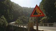
As a result, the old Gorges Road became a little-used byway, often forgotten or ignored by modern motorists. This is a pity because Bain’s beautiful old road is still there, tarred and ready to use, and it’s toll free. So, next time you are driving from Plett to PE, give yourself a couple of extra hours and take the Gorges Road, now labelled the R102, to Nature’s Valley. It’s wiggly and it’s slow, but it is lovely.
The Bridges of the N2
It’s strange to think that the current N2 between Plett and Storms River Village only opened in the 1980’s. Before that, the single route through the intricate Tsitsikamma Forests was Thomas Bain’s Gorges Road, now the R102. The reason it took so long to build a modern freeway through this part of the world is not because of the thick forests, but because the high-lying plateau is gouged by several sheer-sided gorges, cut into the rock by eager rivers desperate to reach the sea. But, when Bain’s road couldn’t be widened to accommodate the specifications of a modern highway, an alternative had to be found.
The only solution was to build a new road along the flat coastal plateau, with a series of large bridges to leapfrog over the impassable ravines. Small bridges over the Storms River, Gourits River and Van Stadens River had already been built in the preceding decades, but the real challenge remained: spanning the mighty gorges of the Bloukrans, the Groot and the Bobbejaans.
Finally, in the 1980’s, a graceful series of single-span bridges were designed to accomplish this feat, and the work was farmed out to three different construction companies. It was one of the biggest construction projects in South Africa at the time. The grand, new N2 toll route was opened to the public in 1983.
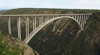
Of all the N2’s bridges, Bloukrans is the most impressive. This used to be the largest single-span bridge in the Southern Hemisphere, and it took three years to build. At the time, it cost a massive eleven million rand. Nowadays, eleven bar won’t get you a condo in Clifton. Construction on the 272 meter arch of the Bloukrans Bridge was started simultaneously from both ends of the gorge and, when they met in the middle, an adjustment of only 10mm was required to match the levels. Not bad, considering that each section weighs 7500 tons. In recent years, the Bloukrans bridge has become better known as the home of the highest Bungy Jump in the world.
Storm's River Bridge
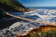
After the excitement of Bloukrans, the next big bridge is the Storm’s River Bridge. More properly called the Paul Sauer Bridge, this bridge was built in 1954 and named after some forgotten footsoldier of apartheid. It has a nice pedestrian walkway, so you can stroll across the ramparts to take in the views, and the nearby petrol station is worth checking out for the interesting photographic display inside the restaurant.
This impromptu exhibit, which hangs incongruously over the heads of diners, details the construction of the various N2 bridges, and boasts an extensive gallery of famous bridges from around the world. I asked the waitress why the restaurant is decorated in such an unusual manner and she, matter-of-factly, answered that the owner likes bridges. Fair enough.
By David Fleminger