
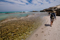
De Hoop Coast
De Hoop Nature Reserve offers a few beautiful coastal walks as well. From the starting point Koppie Alleen car park, you can walk in either direction: westward past the dune fields towards Arniston.
The latter walk would be about 3 km long, falling almost entirely within the reserve boundary. The western walk would be about 35 km long if done in full. These would both be long day outings, where you could plan to be collected at the end points.
The nearby boardwalks carry you over the dune section until the path reaches either the limestone cliffs above the sea or the dunefield area (depending on which boardwalk you take). You should take the long boardwalk directly toward the sea, bearing left at the end.
Along the first 200 m of coastline are some magnificent rock pools, scoured into the sandstone intertidal sea bed below the cliffs. If you take goggles and a snorkel, you can explore the colourful circus of the intertidal rock pools: hermit crabs vying for bigger and better shells, anemones with stinging tentacles, spiky urchins sliding across the algae-encrusted rocks, predatory starfish cornering small molluscs, tiny rock fish, red bait and alikreukels, and even the occasional octopus.
It is possible to follow an imprecise path along the cliffs and across the sandy coves and, depending on the tide, on the rocky intertidal ledges. Coming back, it is easier to follow the equally imprecise paths through the low prickly scrub on the dune sands behind the coastal cliffs. Doves and redwing starlings are common residents in the cliff apartments, and the occasional rock kestrel may be seen here.
Struisbaai to Waenhuiskrans
The route is a long one, but you can make it half the length (16.5 km) by starting at Die Mond, where you must collect a permit during normal office hours. If you choose to start at Struisbaai, you must still collect a permit on your way through Die Mond. For most of the way, the walk is an easy one along firm beach sand.
However, for about four hours around high tide, you are forced to walk on the softer, often sloping beach above the high-tide mark. This can cause your ankles to take strain and your calf muscles to ache a little, but with the wind in your hair and the world open before you, what should you care.
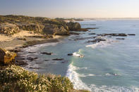
The route from the Struisbaai resort follows a path across a wide arc of open beach. This is a beautiful, unspoiled stretch of coast, where the members of your group are likely to be the only people you will see for the duration of the hike. The solitude and starkness of this hike make it perfect for appreciating the overwhelming sound of the surf and sea birds, the delicate interplay of hues between water, sand and sky, the dynamic artistry of waves, and the static yet transient form of flotsam on the beach.
Your arrival at Arniston will be heralded by the appearance of coastal limestone cliffs, creating ledges and rock pools that should be observed when the tide is out. The most famous feature of the intertidal zone here is the Waenhuiskrans. This enormous sea cave is a protected place, where, according to legend, a group of trekboers hid from British soldiers. The cave's name means 'wagon house', not, as many people believe, because it was once used to house wagons, but because it is big enough to do so.
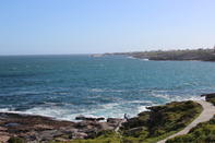
Walker Bay
The Walker Bay hike takes you around Walker Bay, the entire stretch of which is a nature reserve from Hermanus to Die Kelders. Although no permit is needed to do this hike, it would be courteous to report at the conservation offices on the main road, on the eastern outskirts of town (opposite the caravan park on Kleinriviersvlei).
As there is no fresh water anywhere on this walk, you should fill up water bottles in Hermanus before setting off. You will need transport to get you to the start and from the end of the walk.
The walk begins in the town of Hermanus, at the historic old harbour. From here a path follows the top of the cliffs along the rocky coastline of Voélklip, allowing expansive views of the bay. You can follow this if you wish, but the more interesting route is across the rocks just above the surf line (if passing between the edge of the town and the sea, but after a few kilometres you reach the beginning of the endless beach). The rest of the walk is along the beach.
At the 5 km mark, you pass the mouth of Kleinriviersvlei, a popular boating and fishing spot which is usually cut off from the sea. A further 5 km on you will come to a rock outcrop that has been hollowed out by wind and wave erosion, and turned into a shelter - should you need one. The beach will most likely be heavily invaded by kelp gulls and other sea birds, but they will retreat as you approach.
On approaching Die Kelders, the dune area at Die Plaat increases in size. At Klipgat se Plaat you make first contact with the calcrete cliffs that characterise the Southern Cape coastline.
Kleinmond Triplets
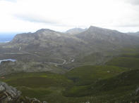
The walk is just one of many that can be undertaken in the Kleinmond Coastal and Mountain Nature Reserve, where a 14 km network of paths has been laid out. The walk is very steep in parts, something obvious at first sight to anyone who looks up the gnarled ridges behind the village.
However, the splendid condition of the fynbos here, and the superb views gained from the summit of the ridge make for a lasting impression. The fynbos is extremely lush and dense, owing to the inception of sea mists and the formation of clouds from moisture-laden winds coming are known as the Palmietberge, after the Palmietrivier below, which, in turn, is named after the restiod 'palmiet' reed that grows along this and other rivers in the South-western Cape.
To the west, you look out across the Palmietrivier Valley to the Hottentots Holland Mountains, dominated by the Kogelberg slightly to the north. Sweeping around to your left, you can make out the Palmietrivier mouth and Kleinmond settlement below; turning to the east you can see across the Botrivier Estuary to the Onrusberge and Danger Point jutting out to sea in the far distance.
From the beacon, the path descends northwards, before swinging sharply left down towards the main river valley. The path makes its way down through the protea-rich veld, crossing numerous small tributaries of the Palmietrivier, to an old firebreak, before circling to the left around the mountain, back to the town.
Quoin Point
The Quoin Point hike follows a route from Buffeljags to Die Dam Caravan Park. This is a diverse hike with sandy beaches, coastal cliffs, vegetated dunes, small settlements, a lighthouse and numerous shipwrecks. It is essentially an easy walk, but the sand along the first and main bays is soft, while, at the adjoining cliffs, the high-water mark is along the base of the cliffs (which you can go behind). The glare from the sea and white beach sand becomes intense with bright sunlight, so sunglasses are recommended, as is a windcheater for the cool southeasterly wind that prevails.
This walk has excellent swimming and fishing opportunities, while the many rock pools afford the chance of observing the fascinating intertidal life. Unless you want to turn around and walk back the long way you have come once you have reached the end, remember to arrange for transport to and from the walk.
Start at the Buffeljags settlement - part holiday sort, part permanent fishing village - situated on a beautiful piece of coastline here rocky shore is interspersed with sandy bays. From here, follow the jeep track that runs parallel to the shore. The track is at first grassy, then sandy, ending at a lovely stretch of beach called Jessie se Baai. In the distance you will be able to see the lighthouse at Quoin Point, and, in front of that, a deserted fishermen's village.
As you approach the rocky shore at Die Kiel directly east of Quoin Point and part of the same peninsula - you may be perplexed by distant grunting sounds. The sound comes from a seal colony on a rocky island about 500 m offshore. Continue past Die Kiel, through the windsheared scrub, and then along a narrow beach of extremely soft sand, often covered with bluebottles and plastic bottles, until you come to the campsite at Die Dam.
 When headed to the Overberg, you’ll find a graveyard of ships and floral riches beyond compare along a coastline patrolled by great white ...