
Eastern Escarpment
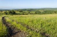
Literally meaning ‘low-lying grasslands’, the Lowveld is situated in the north-eastern part of South Africa, extending into Mozambique in the east, Zimbabwe in the north and Swaziland in the south. It is a region characterised by scrubby bush, comprised of smallish trees (such as the thorny acacia and leafy mopane families), shrubs and numerous grass species.
Also called the ‘Bushveld’, this humid region is cut-off from the cooler, high-altitude grasslands of the interior (the Highveld) by a line of mountains that runs north to south in a great escarpment.
A sharp spine of rocks thus separates the high plateau in the west from the Lowveld and its adjoining coastal plains in the east. This ‘Eastern Escarpment’ is an extension of the famous Drakensberg mountain range in KwaZulu-Natal and, rather usefully, acts as a barrier for the malaria-carrying Anopheles mosquito. So, as a rule of thumb, if you descend from the mountains into the Lowveld, you are in a malaria area.
Numerous Rivers and Streams
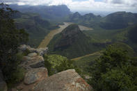
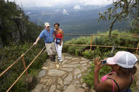
The sheer face of the Eastern Escarpment is spectacular and there are several viewpoints (such as the well-known God’s Window) perched along the very lip of the range. Standing on the edge of the Berg, in clear weather, you can look out over the trees and bushes of the sprawling Lowveld plains, nearly 1000 metres below.
The famous Panorama Route from White River to the Blyde River Canyon takes in God’s Window and a dozen similarly scenic delights, and can be easily incorporated into your Kruger National Park itinerary.
From the foot of this so-called ‘Golden Escarpment’, the flat plains of the Lowveld spool out to the East for about 100 km. This rugged and remote range runs in a remarkably straight line from north to south, roughly parallel to the Drakensberg escarpment. The Lowveld of the Kruger National Park is thus cradled between these two mighty massifs.
Numerous rivers and streams run across the Lowveld. Most emanate in the Drakensberg and flow in an easterly direction through the Kruger Park. The major rivers, moving from south to north, are the Crocodile River, the Sabie River, the Olifants River, the Letaba River, the Shingwedzi, the Luvuvhu (or Pafuri) River and the Limpopo, which marks the border between South Africa, Zimbabwe and Mozambique. Where these rivers meet the Lubombo Mountains, they carve a passage or ‘poort’ through the rocks and continue flowing through Mozambique to end their journey in the Indian Ocean.
Lowveld Geology
The bedrock of the Kruger National Park is granite. This layer of igneous rock was formed around 3.5 billion years ago and is one of the oldest rock layers found anywhere on Earth. The tough, weather-resistant granite has now eroded into the koppies and rolling hills that characterise the southern part of the park, notably around the Pretoriuskop area.
On top of the granite, a series of shale and sandstone layers were deposited. These contain animal and plant fossils along with deposits of coal; indications that the land was once wet, swampy and teeming with prehistoric wildlife. The soft shales have now eroded away to form the flat, grassy plains that run along the eastern side of the Kruger National Park.
After the sedimentary shales were deposited, there was a massive outpouring of volcanic matter that flooded the Lowveld. This flow of molten basalt was released when the supercontinent of Gondwanaland split apart to form the southern land masses that we know today. The igneous layer of ‘flood basalt’ has now formed into flat plains, pockmarked with water holes.
Lubombo Mountain Range
Later, the land split again as the large island of Madagascar started moving away from the African mainland. This caused the land adjacent to the coast to tilt up, creating (amongst other things) the Lubombo mountain range that runs along the eastern boundary of the Kruger National Park.
In the north of the park, around the Punda Maria rest camp, the geology is characterised by sandy soils which have formed into beautiful sandstone mountains. This area is classed as Sandveld and chemical analysis has shown that the soil is similar to that found in the Kalahari. It has been proposed that an era of severe sandstorms transported this sand halfway across the country, from the Kalahari to the Kruger National Park, about 100 million years ago.
As each of these rock layers weather and crumble into small particles, they form soils with different chemical compositions. These soils, in turn, each support a distinct ecosystem with its own characteristic assortment of plants, trees and fauna. The eco-zones of the Kruger National Park therefore correspond with the underlying geology of each region.