
A Great Two-day Hike
This hike is from the rest camp to Grindstone Caves, overnight stop, then up to the Contour Path, heading generally to the south to the Injisuthi Valley and back to the rest camp. It covers a distance of 19 km, and can be done over two days; 1 and a half to 2 hours to the caves, and 6 hours return. It is quite strenuous.
This is a great two-day hike, which can be increased to three days by linking it to Wonder Valley Cave; if you do that, it is recommended that you spend the first night at Wonder Valley or your second day will be an epic. There's no other sensible way between the two caves except via the rest camp, so just accept it and enjoy a cold drink on your way through.
At Grindstone Caves take the path up between the two caves to climb Old Woman Valley and onto Gibisila Ridge, which is a pleat in the skirt of the Old Woman Grinding Corn. After 1 km of steady uphill work the path splits around the ridge, a T-junction. From there the path heads up the inner, right-hand flank of first the Injisuthi and then of a northern tributary below the Old Woman.
After a further 3 km of climbing, gaining about 250 m along this stretch, you finally reach the Contour Path, where you take a breather and then turn left, south-east. Very soon you start your descent flight, down an eland fence. Eland are indeed plentiful in this area, and you'd be unlucky not to see them between here and Junction Cave.
There's a gap in the fence after 500 m, where the path veers sharp right to descend a long, steep valley going upstream. The stream is unnamed on the maps but I refer to it as Junction Stream as it meets Buttress Stream at Junction Cave. The path crosses the stream and heads down the right-hand bank, This is still the official Contour Path, hard as it may seem in some places.
The Molar
It’s not shown on Slingsby's map but, soon after you cross a side tributary from the right, a path heads off around the spur to the right and makes its way into Buttress Fork Valley, reaching this stream at Marble Baths. As you look up this valley The Molar (3 045 m) bites into the sky. This, by the way, is the base of Leslie's Pass.
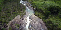
From Marble Baths go down the right-hand bank, which takes you past Junction Cave after 730 m. Although it was popular in days past as a shelter, the cave is close to the river and its roof has partly collapsed and flooding has made it unusable. Where the streams converge and the forest begins, the path seems to go all over the place, crossing the river here and there then finding its way onto the steep, heavily eroded right-hand bank for the last 1.2 km to the confluence with the Injisuthi.
The first part of this section is pleasant, along the forest edge of the left-hand bank, but the latter section decidedly uncomfortable, crumbling in places. Cross the Injisuthi where you come to it, with luck the stepping stones will not be covered, and join the Battle Cave/Lower Injisuthi Cave path. From here on it's an easy 5-km walk along a good, wide, well-maintained path.
By David Bristow