Natural Wells
Because of the way in which the Transvaal sequence has been lifted up, The dolomite layer lies to the west of the Quartzites, behind the higher crests of the escarpment. Rain water forms weak carbonic acid when it percolates through dolomite, eating out hollows like the Echo Caves and the Sudwala Caves.
The Black Reef was laid down initially as beach-type deposits and was later metamorphosed by the tremendous heat of the same volcanic extrusions that thrust it upwards. The intermittent layers of dolomite are derived from the carbonate remains of tiny marine creatures that settled on the floor of a primeval sea once the period of sand deposition had ceased.
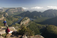
The Blyde River begins its life near Sabie and flows northwards past Pilgrim's Rest, under an arched stone bridge and onwards to the gorge and famous potholes at Bourke's Luck which have been bored into the dolomitic bedrock by the river's scouring action. The potholes are named after a prospector who correctly surmised that these natural wells would be ideal traps for heavy gold particles, washed out from surrounding gold-bearing veins.
View Sites
The village of Pilgrim's Rest arose during the gold rush there in the 1870s, but after World War Il the mines petered out and the historic village drifted into a prolonged sleep. Its brightly painted corrugated iron houses and shops, and the pretty gardens along the gurgling Blyde (happy) River now constitute a fully restored national monument.
The Royal Hotel, however, never closed its doors; to satisfy thirsty miners a bar was brought up by ox wagon from Lourenco Marques (now Maputo), where it had begun its service to mankind as a church.
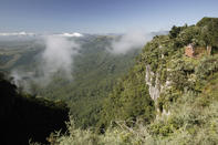
At God's Window one looks out over the sheer precipices and across the hazy, pale Mpumalanga Lowveld bush a kilometre below - when the view is not obscured by the clouds that so often cling, shroud-like, to the soaring cliffs. Beginning at this viewsite, the Blyderivierspoort Hiking Trail wanders off down the valley of the Treur River among the wooded hills, branching off upside valleys past high waterfalls and otter-inhabited backwaters, to meet the Blyde River at Bourke's Luck. From here the trail hugs the rim of southern Africa's second deepest canyon, until one descends between the mighty walls of Swadeni.
The Quintessential Spirit
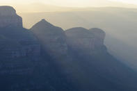
The 800-metre-high turrets of Mariepskop and the Three Rondavels loom over the entrance to the Blyde River Canyon, guarding one of the few passages through the fortress of the escarpment. The Transvaal Sequence rests on a granite floor two billion years old which paves most of the Lowveld and forms the boulder koppies in the southern section of the Kruger National Park. The park preserves the quintessential spirit of old Africa, having been brought about by the word, the deed and the law of three far-sighted and determined men.
The Lowveld was the uncharted hunting ground of The South African Republic. Even then President Paul Kruger realized that in order for his grandchildren to see lion or kudu in the wilds, something decisive would have to be done to preserve this fast-vanishing heritage. In 1898 he proclaimed a 'Gouvernement Wildtuin' here, later known as the Sabie Game Reserve.
In 1902 Major Stevenson-Hamilton was appointed as the reserve's first guardian. He devoted the next forty-four years of his life to its protection and in the process became a living legend. Intervening wars and the dissent of local farmers and hunters did little to further conservation efforts in the Lowveld. In 1926, however, the Minister of Lands, Piet Grobler (one of Kruger's grandsons), pushed the National Parks Act through Parliament, proclaiming the Kruger National Park as its first ward.