
An Extreme Hike
The pass was named after Leslie, the son of Roden Symons who became the second warden of Giant’s Castle Game Reserve in 1906. Leslie’s is the only viable pass in the Injisuthi area:
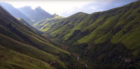
Ship’s Prow tops out 6.5 km to the north-west, and Bannerman about 13 km to the south-east, there is a Corner Pass before that but it’s not used by hikers. That alone is one reason why Leslie’s is fairly well used, even though there is nothing much of interest where it tops out. But it does give access to the upper Injisuthi area, including the Upper Injisuthi Cave and Mafadi Peak, the highest point in South Africa at 3 450 m; Slingsby has it as 3 446 m.
Take the route out of camp, starting down the road, towards Battle Cave and the Injisuthi Valley, past Boundary Pool. Around 4.75 km from camp you turn right off the main Battle Cave/Lower Injisuthi Cave path to cross the Injisuthi and head up the left-hand side of Buttress Fork Stream.
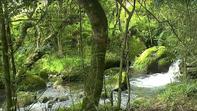
After 1.3 km this path turns sharply left to ascend the sometimes awkward slope, before levelling off and returning to the river at Marble Baths, 3 km from the turnoff to Injisuthi. Just before you reach the baths you'll pass Marble Baths Cave on your left. This is 8.5 km from the start, so you can see you'll need an early start to get up the pass in one day.
Looking up Buttress Fork Valley, you should be able to see The Molar sticking up above the Little Berg slopes on the right. The river is named after Injisuthi Buttress because its main tributary rises on the watershed above it. For the first 2.5 km the pass keeps to the left-hand bank of the stream. It then crosses the stream between two side streams on the right and 1 km along and 300 m up proceeds up spur leading directly to The Molar. This is a steep and tough section, but not more so than several dozen other passes.
More Than a Stroll
There are any number of shorter walks from the rest camp, such as to the yellowwood forest, about a 6 km, 2 hour round-trip of the Del'mhlwazini/Cowl Fork Stream, past the two old guard huts, or up one of the other rivers - the Old Woman Stream or Injisuthi River, or down the Injisuthi for just 1 km to Junction Pool, where the Del’mhlwazini meets the Injisuthi, but as they are so short and easy, they hardly need any more descriptions than that given on the maps.
If you’d like to do a short walk, particularly families with small children but you’re unsure of directions, buy a walking-route brochure at the office. Because of all the stream junctions in the area, and the dense riverine growth in places, the hardest part of these walks is often just getting on to the right path at the start. Don’t be afraid in persisting to get the description exactly right.
Failing that, just point your nose in the right direction and you will get there just as well, other than meeting the occasional dead-end in impenetrable bush or reeds. If you do only one short walk here, then choose the guided walk to Battle Cave, which gives you a sense of the area’s varied habitats, great views of some of the higher peaks and access to one of the Berg’s special rock art sites.By David Bristow