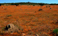
The settlement of Kharkams, 25 kilometres to the south of Kamieskroon on the N7 in Namaqualand, is an excellent flower spotting site.

The name means ‘gathering place of the Nama near abundant water’ and is part of the old stock farmers’ route between Leliefontein and Bethel’s Klip (an archaeological site which shows evidence of human occupation dating back over 800 years).
The huge boulders at Bethel's Klip were also used as a pulpit from where a Rev. Shaw gave sermons to the local Khoikhoi. This has given the site its alternative name, ‘Preacher’s Rock’.
Systershoog Pass
The naming of this long and interesting pass causes plenty of confusion. On the government map it is labelled as Systershoog Pass. This name has been altered by several map sources to read Syfershoog or Syfershoogte Pass. To add to the confusion, it is known locally as the Maermanskloof Pass, the Spoegrivier Pass and the Kharkams Pass.
In Namaqualand the manner of word construction is somewhat different to the rest of South Africa and the naming of any word ending in 'heights' is called a 'hoog' as opposed to the more grammatically correct 'hoogte'. Thus many names in this region end with the word hoog, which is the correct official name.
The Systershoog pass 16,2 km in length and contains 38 bends, corners and curves - some of which are very sharp and have negative banking. The road follows a very different vertical profile to the usual classic pass shape and ends in a steep descent down into the Spoegrivier valley. It connects the town of Kharkams in the east with Spoegrivier in the west and provides an alternative (and much slower) route to Hondeklipbaai.