Enjoy the Valley
This hike is from the rest camp up the Injisuthi Valley as far as the path goes. It is a 17 km return and can be done in about 4 hours up and 3 hours or over the course of two days.
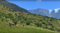
The Lower Injisuthi Cave remains among favourites as it's a very easy morning's or afternoon's walk out from the camp, and gives you access to the inner recesses of the Triplets area which is one of those very special places in the Berg where you can feel the power of the dragon mountains, with Scaly peak rising up on the right. Time your departure to include the guided walk of Battle Cave and you're two-thirds there. The first 5.5 km of the outward walk is to Battle Cave.
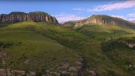
All that remains to be said about this section is how awesome the valley is: the silver ribbon of river running between the hunched, red shoulders of the Little Berg gorge, the rich green of the grasslands fading to an even more intense green of the forest on the opposite bank, the sub-Alpine grasslands ahead sweeping up to the massed ranks of dark basalt warriors — Trojan Wall and Red Wall, two Injisuthi buttresses with the Triplets at the head of this fossil army. Having marvelled at this window into Late Stone Age culture, continue from the cave, along the fence through rank grass down to the river, which is crossed to the right-hand bank after about 650 m, once you've passed the small forest patch.
There is a sandstone embankment on the left and thick bush on the right, with numerous places beside the river to stop for a break, or a dip. For the next 2 km the path crosses back and forth, four times, and it may be a little tricky at times to see exactly where it goes, but as long as you keep taking the line of least resistance you'll get back onto it.
Rushing Waters
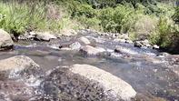
Where the river cuts a small gorge through the sandstone band the path leads up to the left where you can look down into its rushing waters. Then it's downhill again towards the river, crossing a tributary where the rushing river has scoured out a series of Jacuzzi pools.
After a short but tricky section over sloping rocks a path leads uphill to the left - don't take it unless you want to get a closer view of the Trojan Wall, or reach the Contour Path jeep track. Rather, carry on along the left-hand bank of the river, through bottlebrush and ouhout thickets to the cave. This is a comfortable overhang, with low stone walling and grass bedding provided by previous hikers for your comfort. It looks down to the river, but is partially hidden by a leafy screen.
Through a gap at the end of the overhang you can just see the tops of the Triplets, but out of sight behind them is a landmark that is even more significant. It's really just a pimple on the watershed 2 km back from the Escarpment edge but, because it rises to 3 450 m, it is the highest point on that watershed and therefore South Africa's highest 'peak' Modern map makers seem to have pulled the name for it, Mafadi, out of a hat, but the Basothos know it as Ntheledi, 'make me slip', probably the name of the river that rises as tributaries north and south of the peak.
The Upper Injisuthi Cave