
Coastal Development
The town of Scottburgh is named after then Lieutenant-Governor of Natal John Scott, and was the first town to be established south of Durban in 1860. It soon became a port with lots of potential and sugar farms and mills sprang up around the town. In the late 1880s a large group of immigrants from the United Kingdom settled in Scottburgh, known as the Bryne settlers. They settled in the area to start a sugar exporting industry to Durban. The town was pronounced a municipality in 1964.
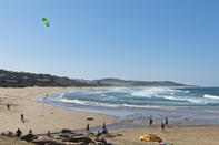
The bay of Scottburgh is situated on the south bank of the Mpambanyoni River, which is a short river that culminates into a lagoon. The Mpambanyoni River mouth has fluctuated in surface area over the years largely due to droughts, cyclones and occasional extreme weather conditions known to the KwaZulu-Natal region.
One of the most notorious above-mentioned cyclones was Domoina of 1984. This was followed by a cyclone in 1987, which resulted in widespread flooding and infrastructural damage, including the destruction of the Old Main Road bridge from Durban and Umkomaas. Interestingly enough, the cyclone caused infant crocodiles to escape from the nearby crocodile park, housing them in the suburb of Freeland Park’s river, which lies north of Scottburgh.