
Fertile Valleys
Before the arrival of the European colonists, the Langeberg area would have been settled, or perhaps used as seasonal rangeland, by semi-nomadic Khoi (Hottentot) groups. However, little is known of the history of these people before the beginning of the 18th century, by which time most of them had sold off their livestock to the settlers and forced themselves (with a little coercion from the colonists) into indentured labour.
The scenic towns that comprises the Langeberg area all have their own unique histories that date back to the 19th century. The town of McGregor was founded in 1861 and was named in honour of the Rev Andrew McGregor, who had been the Dutch Reformed Church minister of the Robertson District for forty years. Swellendam was established in the 1800’s as a trading centre for export goods to and from Cape Town. Montagu lies between the Keisie and Klngna Rivers, and was officially named in 1851. Roberston was established in 1853 and named after its founder Dr Robertson, then pastor at Swellendam.
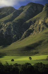
The valleys created by the Langeberg Mountains are known for their fertile soils, with the Roberston district being one of the largest wine-producing regions in the country. Due to the area’s low rainfall, 25 km of irrigation canals stretch from the Breede River near Roberston as far as Montagu. Keisie Valley is currently a major fruit-producing area.
There are four passes that run through the Langeberg Mountains, allowing for safe travel between towns and to other regions in the Cape Winelands. Cogmanskloof Pass links Montagu with Ashton, Tradouws Pass links Barrydale with Swellendam and Heidelberg, Garcia’s Pass link Riversdale and Ladismith, and lastly Cloete’s Pass links Mossel Bay with Ladismith. The passes all make for a beautiful drive as Langeberg’s natural landscapes are on display.