
Scenic Beauties
The section south of Port St Johns is a personal favourite, where short walking days allow for extensive exploration.
It also has some outstanding features, not least of which are the mangrove swamp forests at Mngazana, the Hluleka Nature Reserve, the hotels at Mngazi and at Coffee Bay, and the many secluded beaches along the way. Since routes taken by different parties may vary considerably, exact distances are not given. However, they are all relatively short, the average being 12 km.
Silaka Bay to Mngazana
Although Silaka Bay is the official starting point you will first have to get there from Port St Johns. Take the tarred road south from Second Beach, which soon reverts to gravel and crosses a causeway over the Bulolu River. Follow the road up Mount Thesinger to the Silaka Nature Reserve, where you can leave your car.
Check in at the ranger's house, and if you intend spending the night at the hut, find out whether it is open. The hut is found in a small wooded gorge in the reserve only about 1 km away. Once at the hut you can take either the higher inland route, or follow the rocky beach to a small bay guarded by Sugarloaf Rock, a small Island inhabited by cormorants.
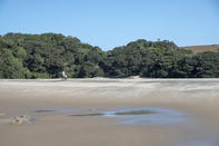
Nearing the Mngazana River the path reaches a grove of river euphorbias (Euphorbia triangularis), a large spiky succulent tree that features strongly in local folklore. The Mngazana River, the 'river of blood', is reached about 6 km from Silaka. A sandbar often chokes the river mouth, while at other times you will have to make an arrangement at the hotel to be ferried across.
Having reached the other side it is another 3 km, either along the soft sandy beach or via an inland route, to Mngazana River, where the finest mangrove community on the Wild Coast is found. At Mngazana River you will need to alert the ferry, which operates by courtesy of the general store here. The hut is situated close to the mangrove community.
Mngazana to Mpande Bay
The beach south of Mngazana River is a jumble of dolerite boulders, and hell to cross. Therefore the path to Brazen Head headland goes by way of an inland route, leading across open grassland, cultivated fields and through small forest patches (although I have known hikers to brave the beach crossing).
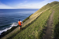
The wild seascapes to the left and tribal African scenes on the hills to the right are the very essence of the trail and the entire Wild Coast. It is perhaps one of South Africa's greatest charms that such traditional lifestyles co-exist with the machinations of industrialised cities. The local name for Brazen Head is Ndluzulu, derived from the crashing sound of angry waves bashing up against the dolerite cliffs.
At Luhlango Village the trail joins a 4x4 track bearing left, and follows it for a short way before heading off along a path to the right over the back slopes of Brazen Head. Descending the hill to the Ndluzula River the path enters a fine patch of coastal forest, where the peeling, greenish-grey bark of the forest corkwood or commiphora tree can be seen. After crossing the river you will have to ascend a steep hill, but are rewarded with views over the Sinangwana River and Mpande Bay, still 3 km away.
On descending this hill the path follows a stream past a rocky section to the beach at the Sinangwana River mouth. It is usually possible to wade across the river, after which a walk along the beach or an inland path leads to idyllic Mpande Bay. The hiking huts are a few 100 m beyond the last cottage and a short way inland.
Mpande to Hluleka Nature Reserve
From Mpande the trail heads inland along an old 4x4 track, to cross the Mtonga River. The trail continues from Mnenu River mouth along the beach for about 15 km to the Hluleka Nature Reserve boundary fence.
The trail turns inland here along the fenceline, to enter the reserve's northern gate, and then winds its way seaward to reach the hiking hut. The 'hut' here is actually an old stone building, being part of the manager's house, and far more aesthetic than the stilted wooden A-frame guest chalets.
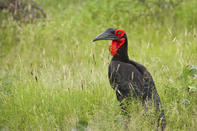
The birdlife is prolific in the Hluleka Nature Reserve, which has been stocked with eland, impala, blesbok, wildebeest, red hartebeest and zebra, while bush pig, bushbuck, common duiker and blue duiker occur naturally. Most interesting here are the forest birds, among which you might see the green coucal and Cape or brown-necked parrot. In the open grazing areas, you might see ground hornbills.
Hluleka Nature Reserve to Ngcibe Hut
From the hut the trail follows the main road to the park entrance and on to Hluleka Village. Leaving the village the trail heads for the coast to reach Banana Bay, named after the wild banana plants that abound in the area. Unfortunately, the fruits are inedible, consisting of a lobed, woody capsule, but the tree makes up for this by producing impressive displays of graceful white and blue crane flowers from July to December.
The path follows the coast to Strachan's Bay. This river presents one of the most problematic crossings of the trail, especially after heavy rains and at high tide. It is a deep estuary, where sharks may be a problem; therefore, the more inland route is suggested, to cross at a fordable place between 1.5 and 2 km from the mouth.
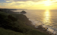
The trail route returns to the beach and continues along it for some way before veering off into the low hills at the end of the beach. The high vantage point inland of Prelies Bay affords grand views over beach and sea, the river valley and its expansive estuary.
About 1.5 km after leaving the beach the path joins a gravel road to the tiny holiday hamlet of Lwandile. Here the river of the same name is easily crossed and, a little way further on, the Lwandilane or 'little Lwandile' River also forded.
The path then rises steeply, before making an easy descent into the beautiful Ngcibe River Valley. The two small huts are tucked away on a stream bank, each affording impressive views of the magnificent coastline.
Ngcibe Hut to Coffee Bay
From the Ngcibe Hut the trail runs parallel to the coastline, keeping as close to the beach as possible, until reaching the Mdumbi River. The river mouth can be tricky to cross, and it is safer to wend one's way a little upstream until a safe crossing is found. The trail then returns to the beach to pass Tshani Village.
From here it is about 2 km to the Mthatha River mouth, the site of another mangrove community. The river flows into a serpentine estuary, and presents the last major river crossing of the hike. If transient sandbars do not provide an easy fording of the mouth, the unreliable ferry will have to be gambled upon, failing which an upstream adventure is in the offing.
The coast from here to Coffee Bay becomes progressively rockier and more craggy; cliffs drop into the sea which makes the beach route impassable. A fisherman's track is followed for approximately 4 km, to reach the tarred main road to Coffee Bay. Having rounded the golf course on top of the flat headland just north of the resort, the road makes a steep final descent to the bay.