
Prospector's Trail
'On this trail you will follow in the footsteps of the early miners along routes that wind past deserted goldmines, along old coach routes and through the historic village of Pilgrim's Rest.
This little town is a reminder of the heady days when gold was discovered and men ordered foot baths of champagne and lit cigars with £5 notes...' so reads the Oliviers' preface to this trail, and what better atmosphere in which to immerse oneself for the six dream-world days of the hike.
Prospector’s Trail will lead to Mac-Mac forest station to Bourke’s Luck potholes and visitors’ centre. Prospecting in the Boer Zuid-Afrikaansche Republiek started in 1853 in the area around the Mac-Mac Falls, but it was only 20 years later that Alec 'Wheelbarrow' Patterson made the first significant strike at Pilgrim's Rest.
This and Barberton soon became the two largest gold rush towns in the Transvaal, bustling with fortune seekers, as well as taverners, bakers, bankers and prostitutes. The mines finally ran dry in 1971, and a few years later the entire village was declared a national monument.
The Eastern Transvaal saw plenty of action in the South African War of 1899-1902; towards the end of the war the Boers established their 'state mint in the veld' near the town, and it was here that the famous gold 'veld-pond' was minted.
Variety of Landscapes
The casual nature lover will find a great variety of landscapes, natural features and habitats to feast the eyes and keep the mind perpetually stimulated. For the more informed naturalist, the area is a fascinating and dynamic interface between biomes and veld types, where many endemic, rare and endangered species of fauna and flora can be observed.
The trail passes through temperate Afro-montane forest on the high-lying eastern and southern slopes and ravines, sour grasslands with ribbons of riverine bush on the high plateaux, and mixed Bushveld on the north and west-facing escarpment slopes within the Blyderivierspoort Nature Reserve.
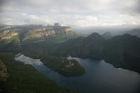
Three Rondavels
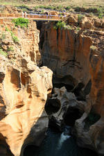
The path encounters some fynbos affinities along the canyon edge, before descending through subtropical gallery forest to true savanna woodland on the hot Lowveld floor. The Blyderivierspoort is, after the Grand and Fish River Canyons, the world's third-largest river-gouged canyon.
From its beginnings just downstream of Bourke's Luck potholes, to its gaping mouth at the Blyderivierspoort Dam, it twists and turns through 18 km and drops some 800 m in altitude. On the fourth day, hikers follow the edge of the canyon, past sentinels such as the Three Rondavels, Swadini Peak, and massive Mariep's Kop, before heading down the Escarpment face to the Lowveld.
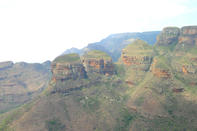
God's Window
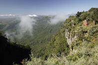
God’s Window to Watervalspruit: the geology of this natural wonder is, in fact, quite simple. The great mountain wall is comprised entirely of very hard rocks known as the Black Reef quartzites. This group is the bottom-most of the Transvaal geological formation that lies underneath and encircles the more central Bushveld Igneous Complex.
The great weight of this latter volcanic extrusion caused the older Transvaal rocks to sag in the middle and buckle up along the edge, like two pavement slabs being pushed down where they meet and lifting up along their outer edges. Because it is so hard, the Black Reef quartzite has successfully withstood eons of erosive forces to form the massed cliffs of the Transvaal Drakensberg.
By David Bristow