
Some of the Highest Peaks on the Subcontinent
South Africa's landlocked Free State Province is the brunt of many jokes, particularly concerning the absolute flatness of so much of it. While it is true that the entire province consists of horizontally bedded Karoo Supergroup rocks, its North-Eastern border includes some of the highest peaks on the subcontinent.
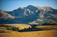
The border area with Lesotho, around Ladybrand, is backed by the massive Thaba Putsoa mountains, while the gem of the province is the protected mountainland of the Little Caledon River catchment area that lies at the North-Eastern corner of the Drakensberg.
Almost the entire surface of the Golden Gate Highlands National Park consists of the highly erodible Cave Sandstones. The park is like an extensive maze, which the Little Caledon River and its tributaries have cut into the sandstone and the even softer Red Bed deposits that underlie it. The Red Beds are undercut everywhere to form caves and parabolic overhangs, like the Mushroom Rocks formation that seem to hang suspended over the roadway, just north of Glen Reenen camp.
Protruding Rock Portals
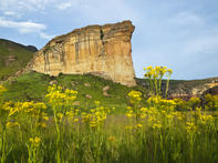
The Little Caledon River has cut itself a deep gorge, leaving great rock portals protruding into the river valley. Interlocking gateways with names like the Brandwag (Sentinel) and Gladstone's Nose characterize the park. The normally creamy-white sandstone bastions have been tinted copper and red by oxidation of the exposed rock; sunset throws a fiery light onto the west-facing walls.
The park is encircled by pyramidal basalt peaks, such as Generaals Kop, Ribbokkop and Wodehouse Kop - remnants of the Stormberg volcanic layer that once covered most of Natal, Lesotho and the Orange Free State.
The point at which the Little Caledon River joins its parent, the Caledon River, marks the fertile valley that became the ancestral home of Chief Moshesh, founder of the modern Basotho nation. He retreated here with the vagabonds and refugees of the bloody Difaqane wars which changed the face of the Southern African interior.
First Thaba Ntsu and then the more impressive Thaba Bosiu - the mountain of the night - were used as natural fortresses to repulse fierce Zulu and Matabele invasions. Later still, sieges and attacks by Boer commandos and British forces failed to dislodge the emergent Basotho nation and their wily, diplomatic leader from their mountain kingdom.
Battle Site of Magersfontein
The Voortrekkers, under the leadership of Piet Retief, out-spanned in the vicinity of the present Golden Gate Park and hunted, departing when their wagons were heavily laden with biltong from eland and wildebeest, blesbok, springbok and rhebok, mountain reedbuck and duiker.
The skins from these animals would have been piled on the floors of the wagons, among lion and leopard hides, perhaps cheetah and serval skins too. Years later, the Boer farmers who settled in the fertile valleys hereabouts, still shot lions by the score.
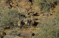
Today, however, the Golden Gate game reserve is too small to support a wildlife ecosystem complete with large predators. Instead, the emphasis here is on outdoor recreation, with many walks and trails, where stealthy hikers can observe the reintroduced game at close range.
The South African War battle site of Magersfontein lies just within the Cape provincial boundary - a randomly drawn line that was one of the causes of that war. When diamonds were discovered around Kimberley, just within the borders of the Boer republic of the Orange Free State, the Cape colonial government simply drew a new border line so as to capture the major diamond fields.
During the early days of the war, the Highland Brigade marched across hundreds of kilometres of the dolerite-blackened northern Cape veld, only to be cut down by the merciless hail of 6 000 Boer rifles. The Boer forces, under the command of generals Cronje and De la Rey, took the British troops by surprise, being concealed in trenches along the base of the Magersfontein ridge.
The British had thought to dislodge the Boers from the crest of the ridge with artillery fire, but lost the battle, as well as 900 troops out of total force of 3 500.
Endless Ranks of Maize and Sunflowers
One of the jokes about the Orange Free State recalls that when the Voortrekkers reached its flat grass plains, they came upon a signpost.
The sign informed those who sought tropical seas, dreams and relaxation to turn right to Natal, while those who wanted wealth and industry were to carry on straight ahead to the Transvaal - and those who could not read stayed put and founded Bloemfontein.
Yet this became a beautiful city, the capital of the most enlightened of the Boer republics, presided over by learned men like President Steyn and President Brand.
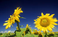
The northern Orange Free State farmers have since turned the country's finest grazing lands into the nation's breadbasket, where endless ranks of maize and sunflowers ripen in the Highveld sunshine.
While the Great Karoo scrublands formerly terminated along the Orange River, decades of overstocking by the Free State's southern sheep farmers have allowed these semi-desert conditions to creep northwards and eastwards into the province, blending imperceptibly with the grasslands.
Biggest Artificial Lake in South Africa
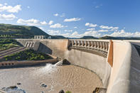
The most amazing thing about the Gariep Dam is not its size (although it is the biggest artificial lake in South Africa), but the amazing Orange-Fish River Tunnel. A network of tunnels, weirs and 'balancing dams' delivers water from the Orange to not only the Great Fish, but the Teebus, Great Brak and Sunday's rivers, all in the Eastern Cape, which has few significant dams of its own.
The main tunnel network is about 80 km long and more than 5 m in diameter. At the time it was completed, in 1975, it was the longest water tunnel in the world. The best thing about the Gariep Dam itself, which can hold a whopping 534 000 megalitres, is the tours conducted inside the massive concrete wall - an engineering masterpiece that extends some 90 m down to the bedrock. A visit here is a definite 'once in a lifetime' thing to tick off.