
Down the Sundays River Valley
It's a long day, granted, but the only hardship you might endure is the fact that there are no hard parts at all, the trail going as it does almost entirely down the Sundays River Valley. You leave town on the R63 S (do not take the N9 to the W), and ride a few km to Adendorp, where you turn right.
Just beyond the dorp, you cross the Sundays for the first of 6 times, as well as several tributaries. The Sundays is the main river in this region, so the valley has fence-to-fence farms all the way - although the river does not always flow, and the farms are not always occupied. Just short of 14 km after the second river crossing our route converges with the S-bound railway line at Hillside (although we could see no hill thereabouts).
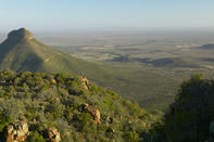
About 1 km later we turn right (W) at a junction and cross the river then swing South again. The land rises up steeply on your right, and the high point opposite is Boesmanskop (1104 m).
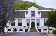
Centre of Graaff-Reinet
Our route picks up the railway again and we follow it South West for 9 km, then turn left near a confluence of routes, heading South East for the next 23 rather - if I say so myself - rather mundane cycling, broken only by 2 stream crossing near either end of this stretch as well, it must be admitted, a slightly more broken landscape.
Shortly thereafter we pick up the Sundays River again, and follow the West bank through a sweeping South formation, head South for about 6 km and then go around another sweeping South formation in the meandering river. Who knew there was a diamond mine here.
This section of the river is by far the most interesting of the day, with more closely packed farms (although most of them are also abandoned), irrigated fields and pastures with fat Karoo sheep (you can almost smell the chops braaiing). Rocky ridges flank the river, and sometimes you have to power over a spur or ride a tight course between ridge and river as you cross over from one side to another. The river here is what geographers call mature, flowing in wide loops through the rugged (but not hilly) topography.
Except in those places where the river has eroded its winding course hard up against a ridge, hills can rise as much as 300 m on the bank opposite the road. In all, you drop from 740 m at the centre of Graaff-Reinet, to 400 m in Jansenville - just 340 m. The total altitude gain won't be much more than that so you could say it's pretty much braai-grid flat again.
If you were a crow, or a black eagle, and you flew to the South East, you would reach the Addo Elephant National Park just 34 km away. It's been a long day in the saddle, but at least the 2nd half of the ride is far more interesting than the first. What it does, if you are in here for the long haul, is sure eat up the miles. And for that we loved it. In terms of finding your way, just follow the river for the final 42 km and it will take you to Jansenville.
Distance: From Graaff-Reinet to Jansenville 114 km
Grade: Long distance, riding moderate but sustained