
Most Rewarding Multi-Day Hike
Route: From Monk's Cowl conservation office via The Sphinx to the Contour Path, and thereon generally northwards all along to the upper Didima Gorge in the Cathedral area.
Distance: 27 km
Duration: 10 to 12 hours (2 days)
Grade: Strenuous to Severe
General: This could be a there-and-back hike but most hikers would consider it a one-way hike between Monk's Cowl and Cathedral Peak. From upper Didima it's a half-day hike down to the Didima/eMhlawazini junction, past Solar Cliffs to the Cathedral campsite, but the route all the way to the northern end of the contour path is much longer. This is perhaps the most rewarding multi-day route along the Contour Path, although transport between the two ends would have to be organised. Just bear in mind that the path at the upper end of the eMhlawazini River has become overgrown in places and this makes progress tedious.
A Tough First Haul
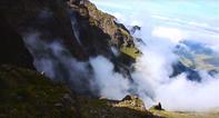
Eventually, you will find yourself signing the mountain register at the park gate, and paying your entrance fee. Take the steep path that winds up the large sandstone prominence called The Sphinx - the main path to the top of the Little Berg. It's a tough first haul but leads to a delightful plateau dotted with silver-leafed proteas, and then a sloping grassy spur to the Contour Path, which is reached 5.5 km from the start. For first-time hikers the views of Cathkin, Champagne Castle, Sterkhorn, Amphlett and Turret rising up ahead and getting ever closer can be overwhelming; try not to hyperventilate.
At Blind Man's Corner turn right to head north along the Contour Path for a delightful 2.5 km, where you weave in and out of about six stream gullies, the mountains rearing up to your left, as you make your way to Hlathikulu Nek where a lesser path turns off to the right. There must be hundreds of 'hlathikulus' in KZN (the word means 'big forest'): this 'hlathikulu' is down the ridge to the east. Our route carries on to the left, looping around two spurs at the base of the Amphlett for 1.5 km till you are standing looking down to the eMhlawazini River 600 m below.
Intunja - Eye of the Needle
The path to the left goes up to Keith Bush Camp at the base of Gray's Pass, while that to the right goes to Zulu Cave. The way to Didima and the last refuge of the Bushmen in the Drakensberg lies ahead, down to the river, which involves a couple of big loop-backs. This point is 10 km from the start and, though not yet halfway to the camping area at the upper Didima River, it's often a midway stopping point. Be ready to bushwhack: this path is pretty much neglected by park authorities and could become overgrown.
Directly in front of you is Intunja, the 'eye of the Needle', or in Afrikaans the less-inspired Gatberg. It's only 2 km in a direct line to the other side of this pointed, holy peak, but to go around it - which you must - will take you on a winding 4.5 km loop around the mountain and over a low nek.
When you reach the first mainstream on the 'other' side, a line directly through the summit is the one to your crossing point of the eMhlawazini. A little over 1 km further the path climbs over the last scale of the Dragon's Back and then cuts sharply back down to a river, the Nkosazana. This is the alternative stop, 17 km from the start. This section has become heavily overgrown and hikers can find it hard going.
Mountain Bubbly
The Nkosazana is a small tributary of the eMhlawazini, but there's nothing small about the huge cutaway of its gorge, where it tumbles over the Vulture's Retreat on its way down from Champagne Castle. I like to think of this water as the mountain bubbly that flows, a never-ending miracle, from the Champagne mountains.
On the way round Intunja you will have experienced something of the waywardness of the Contour Path. For the next 7 km it does more of the same, looping round innumerable streams to round the Litter and then slowly gain altitude as the path takes you parallel to Eastman's Ridge (named after 'Grandpa' Eastman who first climbed the high pimple on it, 2 580 m, at the Mountain Club's July camp in 1935).
Finally, on a spur opposite a lesser pimple on Eastman's Ridge (2 408 m) where a path leads off to the right down a long peninsula, or isthmus, of the Little Berg, you will have reached the highpoint of the hike, at 2 150 metres. The large bowl-shaped valley in front of you (the Mmesini), and the one beyond that, leads down to Didima Gorge. The Contour Path continues to the left, to maintain its general course along the base of Eastman's Ridge, but now keeping on the contour instead of the usual upping and downing, but mostly upping, since the start of this hike.
World's Greatest Outdoor Art Gallery
At the head of the Mmesini a path leads to the left, into the Eastman’s Peak fork Stream. It’s a go-nowhere route but an interesting 8.5-km detour into this seldom visited side valley of the Didima that will bring you around, eventually, to your end point. If you don't have time or the energy then just carry on along the right-hand side of Eastman's Ridge for another 2 km, while the path loops around a little obstacle and then proceeds down between two small grassy spurs for another 2 km to the edge of Didima Gorge.
First-time hikers in this area might want to brace themselves for the awesome sight, you have reached a very special place, The area around you, described in a 5 km arc to your right, is the world's greatest outdoor art gallery. In a few dozen caves and small overhangs are thousands of paintings executed in polychrome pigments, in the finest detail, by Bushman shamans, over thousands of years. They tell us all we know about the Bushmen, their lives and their supernatural beliefs. One man, Harold Pager, spent several years in this valley, recording every single image in a mammoth publication called Ndedema. It's hard to find a copy, but if ever you do you should take the time to study it.
Sound of Thunder
The gorge drops away over the sandstone lip of the Little Berg to a wooded, boulder-choked chasm. Didima can be translated to something like 'sound of thunder' and it's an appropriate name for this place where the river tumbles and roars through the gorge. It's also a fine name for the two highest points on the Escarpment, Didima Dome (3 078 m) and Didima Buttress (3 130 m), as the name can also Imply 'the place of thunder', or a place where storms are born.
Some of the highest points in South Africa lie on the high ground some kilometres behind Witch Peak (3 062 m) to the south of Didima Buttress. They lie on the watershed and are unnamed but four of them are over 3 300 m high.
Absorb the Deafening Silence
Taking your gaze away from such lofty things and getting back to the much more earthy business of finishing your hike, turn left at this intersection on the rim of Didima Gorge to cross the river after another 500 m. There is plenty of flat ground to set up your tent and absorb the sublime, deafening silence. When I dream of camping in the Drakensberg, it is of this place.
There are three caves in the area that you can book. The closest to this spot is Schoongezicht, about 500 m up the valley on the left-hand side, on the lower slope of Eastman's Ridge and facing due west towards the top of Organ Pipes Pass (it is a small shelter, sleeping only four and to be avoided in wet conditions).
The second is Leopard Cave. Take the path along the upper rim of Didima Gorge for 5 km to where it turns off to the left through the cliff band to the bottom of the gorge: turn right here to cross a side valley and stream and then climb up to the edge of a grassy plateau where you'll find a large shelter.
Reach Poacher's Cave, also large, by carrying on along the main path to the bottom of Didima Gorge, then heading back up the left-hand bank of the river for just over 1 km. The cave is in the cliffs looking down to the river. The quickest way of reaching Cathedral is a one-day hike from the upper Didima campsite, down Didima Gorge to the eMhlawazini junction, then down the eMhlawazini past solar Cliffs to Cathedral (Mlambonja) valley road.