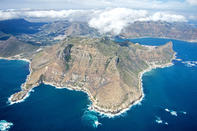
Karbonkelberg Traverse

Route: Hout Bay to Llandudno around the coast
Distance: 12 km
Duration: 6 hours
Grade: Moderate
Although it involves some tricky traversing around cliffs if tackled at the high tide, this is one of the most satisfying walks on the peninsula. The waves' constant drumming on the rocks creates soothing music for the duration and there are numerous coves for bathing if you begin to overheat. The tricky traverse around the steep cliffs of The Sentinel gives a tougher grading to what is essentially a level path. The walk is linear, so be sure to organise transport to and from the beginning and end (parking at the end is in Leeukoppie Road; follow the signs to Llandudno and Sandy Bay from Victoria Road).
Plan your hike to coincide with the low tide for the first section, so that you can boulder-hop across the rocky seashore around The Sentinel, thus avoiding a climb as high as 20m above the sea. This higher route, although feasible, is potentially dangerous and not for those who have a fear of heights and slippery rock ledges. At the best of times, this is not an easy hike, and you should set aside the better part of a day to complete it. There are short cuts, such as the path over the saddle between The Sentinel and Kapteinspiek back to Hout Bay.
Kalk Bay Caves and Waterfall
Route: Die Ou Kaapseweg to Kalk Bay and back
Distance: 10.5 km
Duration: 3 to 4 hours
Grade: Fair
Booking Authority: Cape Town Parks and Forests Department (no permit needed)
The name of this area, Silvermine, dates back to 1687, when Simon van der Stel, in one of his many efforts to find the legendary mineral wealth of Africa, had his miners dig in the area for silver - of which they found nought. Although the route description begins on Die Ou Kaapseweg, it could just as easily begin on Boyes Drive above Muizenberg, or, for a much longer walk, from Tokai State Forest below Constantiaberg.
 Lying at the south-western tip of Africa, the Cape Peninsula is on the Atlantic side of South Africa. A spectacular view of the Cape Peninsu...
 The major reason for retaining the Western Cape mountains as pristine natural regions is that they are important water catchment areas in an...