
Self-Drive to Vedefort Dome
The gateway to the Vredefort Dome is Parys, an attractive holiday town built along the south bank of the Vaal. To reach Parys from Johannesburg, take the N1 South, following signs to Bloemfontein. After you pass through the Grasmere Toll Plaza, the tough urban landscape gently transforms in rolling agricultural fields.
About 80 kms outside of Joburg, you’ll cross the tall bridge over the Vaal River into the Free State. After another 10 kms (roughly 90km from Joburg), take the exit marked ‘R59 – Parys/Sasolburg’, just before the Kroonvaal Toll Plaza.
Turn right at the top of the off-ramp and drive 20 kms until you reach Parys. A short distance into town, the main road into Parys (Loop Street) hits a stop sign and takes a sharp bend to the right (Water Street) and then to the left (Breë Street). Follow this dog-leg into the main tourist thoroughfare, Breë Street; a wide boulevard filled with restaurants, antique shops, art galleries and shops, offering many happy hours of browsing.
When you’re done, continue down Breë Street until you get to the first (and only) traffic light in Parys. From here you can keep going straight to reach the small town of Vredefort (15 km). Alternatively, you can turn to the right, cross the attractive bridge over the Vaal, and head towards Potchefstroom on the R53 (about 50 km).
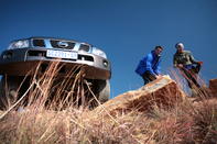
The Vredefort Dome Mountain Land is clearly visible, rising up along the north bank of the Vaal, and can be accessed from either of these two tarred roads. The gravel roads that wind through the Dome Mountain Land offer the motorist many different routes and options. The scenery is spectacular and the atmosphere is peaceful and rural.
Do note, however, that the secondary roads through the valleys can become quite rough. Grading is done on an irregular basis and some patches are badly corrugated. You certainly don’t need a 4x4, but a car with good suspension and reasonable ground clearance is preferable. Get a map of the area from one of the tourism bureaux in town to avoid getting too lost.
A Suggested Round-Trip from Parys to Vredefort Dome
At the traffic light on Breë Street, turn right onto the R53 to Potch. On the far side of the bridge, you will see Jalapor’s General Dealer shop. This trading post has been serving Parys since the 1920s and still has many of its original fittings. It is located on the wrong side of the river because Indians were not allowed to own shops in the Orange Free State.
After 2 km, you come to an intersection with the R500 to Fochville. Turn left and keep going on the R53 towards Potch. 10km out of Parys, turn left at the sign for Venterskroon. The road now becomes gravel as you descend into a fertile valley between two of the Vredefort Dome’s ridges. After a few k’s, you come to a narrow bridge over a beautiful stream. There is a turn-off to the left marked ‘Koppieskraal’. This is a short-cut back to Parys with fantastic views. If you keep on straight towards Venterskroon, the road leads along a dramatic ridge of upturned rock.
The huge forces at play in the Vredefort Dome begin to become apparent. Stop at Thabela Thabeng guest farm for a quick look at their interesting geological display. 15km from the tar road, you arrive in Venterskroon. The old mining village is looking good and several new facilities (including a coffee shop and an info centre) await visitors. When you’re done, the road continues through Venterskroon and up a small pass. This brings you out at the farm Leeufontein, one of the oldest in the Transvaal. You’ll then come to a cross-road.
Turn left. After a short distance, you will come to a T-junction with the Schoemansdrift-Potch road. Turn left towards Schoemansdrift. Farms dot the hilly landscape as you continue through the Dome, down towards the Vaal River. After a few ks, there is an intersection with the Skandinawiëdrift road. Keep left towards Schoemansdrift.
Schoemansdrift is a long, single lane causeway over the Vaal River. The setting is gorgeous, and the bridge is a favourite spot for the local fishermen. On the other side of the Vaal, the road hits a T-junction. Turn left and wind your way along the south bank of the river.
There is a rather confusing network of gravel roads through this part of the Vredefort Dome, so get a map from one of the info centres before you set out. It’s hard to get too lost, though, because all the roads eventually lead to the tarred road that links Vredefort and Parys (R59). When you hit the R59, turn left to go to Vredefort or turn right to return to Parys. The round trip shouldn’t be more than 100km but you don’t want to rush it, so get an early start.
Alternative Route to Vredefort from Potchefstroom
The other way to reach the Vredefort Dome Mountain Land is from Potchefstroom. To reach this busy little town, take the N1 south to Bloemfontein. After about 20 kms, there is a split between the N1 and the N12 (marked for Potch and Kimberley). Take the N12 and head along the prominent ridge of hills for about 100 km.
On the way, you will pass Mponeng Mine, the deepest in the world. Once you reach Potch, follow signs for the R53 to Parys. This will bring you into the Vredefort Dome Mountain Land from the north. As a final note, when you return to Joburg, the roads can be a bit confusing. As you near the metropolis, you will see a sign for the N1.
This will take you on the concrete highway (more correctly known as the Western Bypass) through Roodepoort to Pretoria. If you want to get on the M1, which leads through the Northern Suburbs to Sandton, follow signs for the N12 to Witbank and then take the slip-road marked ‘M1 North’. Improved signage could help this complicated little manoeuvre, which catches me out every time.
By David Fleminger