
Indigenous Forest Scenery
The village of Storms River is often confused with the Storms River Mouth. People tend to speak about the two interchangeably when, in fact, Storms River (or Stormsrivier as it is also known) is a little village just off the N2 outside the Storms River camp of the Tsitsikamma National Park. The village is named after the Storms River that winds its way to the east of Storms River village, culminating in a breathtaking river mouth within the Tsitsikamma park.
In the area are a number of fairly easy hikes: The Ratel Trail or nature walk is a 4.2 km walk that will take you about an hour and a half to complete, but there are shorter versions of the circular walk if you do not have the time. The walk surrounds the famous Tsitsikamma Big Tree, which you will find east of the village.
There are three interlinking routes – a green (1 km), yellow (2.6 km) and red route (4.2 km), each of which follows a slightly different route through the forest. Plaatbos Trail follows a route through high indigenous forests south of the N2 in the Plaatbos Nature Reserve. There are four options – green (5 km), red (7.8 km), and yellow (8 km).
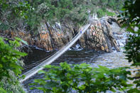
All the routes begin and end at the Forestry Office in Storms River village. The most exciting is the yellow trail as it includes the Storms River Bridge and the picnic site. Goesa Trail is a short walk, only 2 km, through indigenous forests. It starts at the SANParks office in the village.