
Table Mountain Challenge
The Destination: The Table Mountain National Park encompasses the incredibly scenic Peninsula mountain chain, stretching all the way from Signal Hill in the north to Cape Point in the south, over a distance of around 60 km.
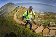
Two world-renowned landmarks - the majestic Table Mountain and legendary Cape of Good Hope – symbolises this protected area, famous around the world for its extraordinarily rich, diverse and unique flora and singular land formation. The Terrain: The area forms part of the Cape Floristic Region and thus supports a high diversity of flora, a lot of it rare and endemic.
\Protea, erica, restios, asteraceae species and geophytes are found in abundance. The routes are mostly along well-trodden hiking trails, often with the occasional steep scramble along the way. Getting There: From the City Bowl, follow the tourism signage to Table Mountain along Kloof Street.
A good place to leave your vehicle is the parking area immediately to your left where you turn off towards the Aerial Cableway along Table Mountain Road. The Trail: Table Mountain National Park is a protected area with an exhilarating selection of trails to suit all levels of runners. There are many routes to choose from along the full extent of the rugged chain, all boasting exceptional views of Cape Town and the azure Atlantic Ocean.
Mast Challenge
The Destination: Cape Town’s premier mountain biking hotspot of Tokai Forest plays host to this trail run with a twist. The Trail: Starting from the Arboretum gate near the Tokai picnic area, the route follows the main jeep tracks that wind up the mountain towards the mast at the top of Constantiaberg Peak.
By mostly keeping right the network of jeep tracks will eventually (about half way up) lead you to the tar road that takes you directly to the infamous Mast 10.5 kms later. The mixture of jeep track and tar makes the terrain very easy underfoot, however the 900m elevation over 10.5 kms makes this a feat of lung-bursting strength and stamina not to be sniffed at.
Two Ocean's Trail Run
The Destination: Cape Town - for those based in the mother city, this event couldn’t be more convenient. The annual event is hosted by the iconic University of Cape Town (UCT) Upper Campus forecourt and sports field. The Trail Head: As there are several trails involved in this route, they usually start and finish at the University of Cape Town (UCT). The route starts climbing immediately and continues for the first 11 km.
The halfway mark (11 km) is at the top of the saddle between Devils Peak and Table Mountain along about the longest, steepest route possible to the saddle. There are three significant “hills” in the first half of the race, the first of which is called Heartbreak Hill.
The second hill is a steep single track switchback up to the cannons on Tafelberg road and from there the climb is up to the middle contour path on Devils Peak. This section is quite a climb but certainly does not qualify as one of the three hills in the first 11 km. It is a long, rocky staircase and is mostly walked.
The upper contour of Devil’s Peak is dramatic, with sheer cliff faces on your right and steep trail dops to the left and requires immense concentration, which is difficult if one is trying to take in the glorious panoramic view of Table Mountain, Devil's Peak, Table Bay and Robben Island.
The trail then swings round Devil's Peak in a gentle route before hitting a scramble above the Blockhouse where runners are forced to walk and climb down a 90-degree cliff face. This is not a race for people suffering from vertigo. The second half has gentle trails and tracks through Newlands forest with the odd inclines here and there until Bastard Hill. This hill is aptly named as it is a single track along a fence which never seems to end. The final section is through a field with uneven terrain covered by grass.
Puffer Challenge
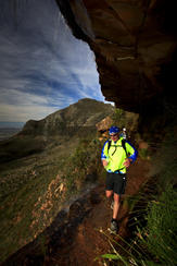
The Terrain: Although you may grumble at the initial 20 km of tar, you will sample the exquisite fynbos single-track and gravelly/sandy jeep track traversing an unspoilt fynbos paradise. Steep climbs along the Old Wagon Trail and towards Elephant’s Eye, stream crossings, zigzag descents and stacks of technical single-track will transport you onto another plane as you pass through indigenous Afromontane forest and endless fields of fynbos.
The section up to the highest point of the whole route – Maclears (at 1 088m) is always tough and more of a scramble than a run, but soon the steep climbing gives way to some faster rock hopping along the ‘table’. On top, it can get very soggy in August, so expect to get your shoes wet.
Platteklip Gorge is a nemesis for many a Puffer runner, but the eye-popping beauty should take your mind off the knee-jarring steps! The Trail: At 5.30 you and 119 other runners set out from the very tip of Cape Point. A much needed head torch will be a boon along the 13 km or so of tarmac to the reserve gate, from where you stick to the tar towards Red Hill for another 8 km. At the top, you finally hit the trails and jeep track for a while as you meander past the dams towards Glencairn Expressway.
Once you hit the bottom of the Old Wagon trail, you can finally whip your trail shoes on, then start the long slog up the rocky jeep track (about 5 km) as you head up into Silvermine Nature Reserve. Pass the dam en route to Elephant’s Eye and continue along the rather rough and ready trail until you pop out onto the Level 5 road in Tokai Forest.
Keep climbing until you reach the tar road to the Sentech Mast, but veer right here towards Vlakkenburg, crossing a little wooden bridge all the way to the top, and then all the way down the other side to Constantia Nek. This is a seconding and re-supply point (as well as a cut-off!), so grab your kit bag and head onto either the Bridle Path or new steps (it makes little difference time-wise).
Ascend to De Villiers Dam and pass the Hoerikwaggo Trail Hut onto a gorgeous section of single-track for more than an hour. Smuts Track is up next: Keep going past Skeleton Gorge junction, heading north towards Maclear's Beacon on a path that is in great condition with steps and well maintained wooden walkways and bridges.
Now set course for the Aerial Cableway station, all the while keeping your eyes peeled for the sign to Platteklip. This is an extremely steep downhill - with many loose rocks, big steps and wire clad gabions – must not be rushed. Look out for the contour path (about 100 m above Tafelberg Road) where you turn left to pass below the cableway.
Now it is very much tar all the way onto Signal Hill road before you hit the final descent to the V&A Waterfront past the Noon Gun. You’ve done it!