
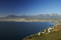
Crossing the Mountains of the Cape
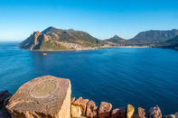
After the establishment of Stellenbosch and Franschhoek, farmers started spreading out across the flat lands that surrounded the Cape Peninsula. They would have gone farther afield but, beyond this deceptive strip of low-lying land, there suddenly rose a barrier of jagged mountains that cut off the Cape Peninsula from all further agricultural expansion.
These mountains ran unbroken from the Eastern Seaboard at Gordon’s Bay to Paarl, near the West Coast. From there they ran north, through the Sandveld, for hundreds of miles before veering gently west to the coast again, thus closing the seal.
Jan Van Riebeeck called them the ‘Mountains of Africa’, and they were an insurmountable obstacle to any form of wheeled transport. The Dutch governors all realised that these mountains would have to be breached if the European settlement at the Cape was going to keep growing, and various expeditions were sent out to find passable routes over the mountains.
Eventually, several precarious egresses were uncovered from the jumble of peaks, but none of them were easy to negotiate.
Path of Least Resistance
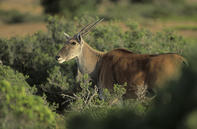
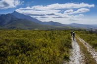
The first passes were usually game tracks, worn out of the rocks by endless generations of migrating animals who crossed the mountains in their seasonal search for good grazing land. Eland, buffalo or elephant were thus the earliest trailblazers, instinctively finding the path of least resistance along the contour lines, until they had forged a track from one side of the mountain massif to the other. After these animals came the Bushmen and the Khoikhoi.
They followed the game and learnt their routes, adding their own footpaths when necessary. Later, when the white man arrived, these prehistoric tracks were often pointed out to the new settlers by helpful Khoikhoi, who had not yet come to distrust the white man’s motives.
Thus, by the late 17th century, white settlers had found their way over the mountains, and were able to gaze down upon the vast expanse of African interior for the first time.
Paarl to Roodezand Valley
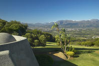
The first documented passage over the “Mountains of Africa” was found by Pieter Potter in 1658. It led from Paarl to the Roodezand Valley (now called Tulbagh) in the North-East. From Tulbagh, other passes were forged over the mountains further to the North, and this eventually gave access to the Ceres Valley and the Great Karoo beyond.
Over the years, this network of road passes was extended and expanded, and for over a century, the ‘Roodezand Passes’ were part of the main road to Joburg.
Overberg
In 1662, Hendrik Lacus documented his ascent of an old Eland’s path over the Hottentots Holland Mountains to the East. This game track eventually became Sir Lowry’s Pass, and it offered access to a broad, fertile coastal plain over the Mountains. This new region was appropriately named the Overberg.
Those were the only options a pass to the north, a pass to the north-east, and a pass to the east. The mountains around the Cape Peninsula were so steep and rugged that only three access routes connected it to the rest of the country. In many respects, the situation hasn’t changed.
Geographically, the Cape remains isolated from the rest of South Africa, and isolation is the first requirement for the creation of a new species. Perhaps that’s why Joburgers like to joke about taking their passports when they travel to Cape Town. It’s like another world, bru.
Piekenierskloof: The Copper Mountain
A pass to the barren North was reported by Jan Dankaert in 1660. It was eventually named Piekenierskloof (Pikeman’s Ravine), and it is still part of the modern N7 from Cape Town to Springbok.
In the early years of the Dutch settlement, this was the most frequented pass of them all, as expedition after expedition penetrated through the Olifants River Valley into the wastes of Namaqualand.
These explorers were spurred on by a simple map that vaguely indicated the location of Vigiti Magna, a glorious city of gold and capital of the fabled empire of Monomotapa. They never did find any gold, but mineral deposits around the ‘Copper Mountain’ were discovered and happily exploited by the expedient Company.
 The Western Cape is a spectacular corner of southern Africa where natural splendour seems to have been concentrated. Ranks of massive grey c...
 If you’re in search of the perfect blend of adventure, leisure and culture, the Western Cape is your Holy Grail of African travel. From th...