
Rich Heritage
Pringle Bay’s history starts at the Stone Age. Around the early 1920’s excavations in the bay area found ancient burial sites, stone tools and wooden fishing tools that suggest early habitation. Further investigations in the late 1970s found caves in the area, that were once home to people of the Stone Age.
In the 1700s, Pringle Bay was to be turned into a port, shipping farm produce from False Bay to the naval base in Simons Town. The port never materialised and the town remained a quiet retreat. During the Second World War, the town’s growth halted as the military occupied the bay and made it a restricted zone.
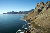
Due to a secret radar station that was built on the side of the mountain above Pringle Bay, which was responsible for tracking any U-boat activity in the area’s waters. A Prisoner of War station was also erected to hold captured Italian soldiers. Interestingly, these soldiers worked to build the coastal road now known as Clarence Drive. The road allowed the town to expand.
The heritage of Pringle Bay and surrounding areas such as Rooi Els and the Kogelberg Mountains are rooted in conservation. In 1937, the Department of Forestry became responsible for the area and made land available to be used as timber plantations.
A local landowner then campaigned for the areas to be conserved, and in the early 1950s, the Western Cape Conservancy helped create the Kogelberg Biosphere and Nature Reserve. Thanks to this, Pringle Bay is still surrounded by lush natural landscapes.