
Self-Drive Route
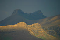
A popular self-drive route starts in Clarens and joins the R26 at Fouriesburg. Here, massed cream-and-orange coloured sandstone buttresses form a pedestal for the basalt spires of the more distant Maloti Mountains, which taunt the huge thunderhead clouds over Lesotho.
This route connects all the lovely old frontier towns of the eastern Free State, all the way to Lady Grey in the northern Eastern Cape highlands. The area was so coveted by both Boer and Basotho that the Brits decided to stop the quibbling by taking it for themselves. It is so calming on the senses now, the earlier strife is hard to imagine. Culturally speaking, it's a bit of an alternative experience, especially in places like Rustlers Valley.
Bokpoort Trail
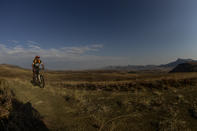
Bokpoort is set amidst sweeping skies punctuated by the soaring Maluti peaks, less than 8km from the picturesque village of Clarens. Surrounded by the Rooiberge, Bokpoort Farm has been part of the Roos family heritage for five generations. There are five trails in the Bokpoort area, ranging from 10 km to 34 km, all varying in difficulty and offering never-ending exploration amidst grassland ridges teeming with game and birdlife.
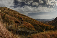
Cool mountain streams offer refreshing dips along the way. All trails start at the office, then pass the stables on the left via two gates before heading towards the river. From here, you can either follow the mountain bike trail along a 4x4 jeep-track up some sandstone rocks or head along the hiking trail through ‘The Eye’ onto higher cliffs. You’ll eventually reach the Bush Camp, from where the brave hearts can head up to ‘George’s Pimple’.
An incredible and unforgettable 360 degree view over the Maluti’s and into Lesotho is your reward for reaching the highest point on the farm. (This is the 34km return option from the office and back.) The terrain at Bokpoort is mountainous; the trails start at 1 800m above sea level and peak at a lung-busting 2 500m. Expect undulating, grassy hills, amber sandstone formations and a number of creek crossings while traversing the farm lands along a mix of jeep track, single-track footpaths and hiking trails.
Golden Gate Highlands National Park Trail
Golden Gate Highlands National Park and the surrounding Maluti Mountain ranges offer an extensive selection of mountain biking options, although the roads inside the South African section of the park are all (rather sadly) tarmac. Get into tarmac cruise mode from Clarens, cranking along the R712 towards the Golden Gate Park entrance (13.4km), and then turning right onto the Blesbok Loop after just on 2km.
This 7km one-way loop climbs steeply into eland country, boasting panoramic views and an inexhaustible supply of fresh air. A skittish switchback downhill will zoom you back onto the R712, where you hit a sharp left almost immediately onto the extended Oribi Loop.
Explore this bonus 4.2km circuit for a highlands crank amidst zebra, wildebeest, mountain reedbuck and chacma baboon, to name but a few of the species. A speedy 22.5km cruise back into Clarens makes for a total riding distance just shy of 50km. Beyond the perimeter of the actual Golden Gate Highlands National Park, the rough and ready gravel roads of the erstwhile Qua-Qua tribal homeland buck and slide along gnarly valleys and craggy horizons.
There is a lot of potential riding here, but note that in some cases, access and/or permits need to be arranged beforehand with private landowners or the parks authorities. Generally, folk up here in the Eastern Free State are so friendly and down-to-earth, that this process will be relatively painless.
By Jacques Marais